4519674443

cc9e51b55412b3219

Explore Bangladesh Tourism

Sunday, December 29

About Bagerhat District, Bangladesh


About Bagerhat District, Bangladesh


Bagerhat district located in the south western part of Bangladesh. Bagerhat subdivision was turned into a district on 23 February 1984. The Geo position of the district is between 22˚32’ to 22˚56’ North latitudes and between 89˚32’ to 89˚48’ east longitude.


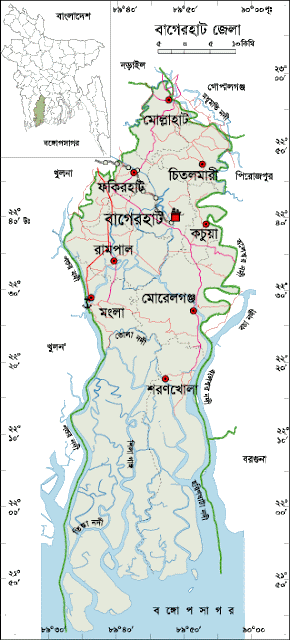
Bagerhat District Map, Bangladesh


History of Bagerhat District

The history of Bagerhat district is very rich. The ancient name of the region was “Khalifatabad.” It is debatable about the naming of Bagerhat. Some historians think that the region is adjacent to Sundarban and the the region once under the raid of tigers (Bagh). So it is called “Bagher Hat.” By the passing of age the word Bagher- Hat turned into Bagerhat. Some researchers think that Bagerhat came from the name of “Baker Hat” that once sat on the northern part of Vhariab River. Some Historians think that the “Khalifa –e- Abad” established by Khan Jahan Ali (R) that Bag (garden) convert to Bagerhat by the passing of age. The name of great saint Khan Jahan Ali (R) is related to the history of Bagerhat. He migrated here in 1429 (debatable) with a number of followers from Delhi and established the Khalifabad Pargana covering areas including Bagerhat, Khulna, Satkhira, Jessore and Barisal. He ruled this pargana during the period from 1429 to 1449. After his death in 1449, Raja Prajapaditya conquered the Pargana. During the British East India Company Period, Bagerhat police station was established in 1842 under Khulna subdivision. The region was upgraded into subdivision under Jessore district in 1863. During the war of liberation in 1971 the Pakistani army entered Bagerhat on 21 April through the land way via Domer-pool. They killed about 200 innocent civilians at Khalishakhali and Babuganj. Many people were killed and wounded in encounters between the Pakistani army and the freedom fighters at Doyapara, Shakharikarihat and at Chakulia of Mollahat. Besides, 35 people were killed in an encounter between the freedom fighters and the Razakars (supporters of enemy army) in Morrelganj. 


Bagerhat District Bordered By-

Bagerhat District is bordered by Faridpur district to the north, The Bay of Bengal to the south, Pirojpur, Barguna and a part of Gopalganjdistrict to the east, Khulna district to the west.


Why is Bagerhat District Famous For?

Bagerhat district has rich historical background. Bagerhat district is famous for Shat Gombuj Mosque, founded by Muslim saint Khan Jahan Ali.


Remarkable Personalities from Bagerhat district 

The remarkable personalities from Bagerhat district are- Dr Nilima Ibrahim (Writer), Sree Das Gupta (Politician), Rudra Mohammad Shahidullah (Poet), Prof. Abdullah Abu Sayed (Writer and Social Worker), Prof. Abu Baker Shiddique, Sheikh Amjad Ali, Kiron Chandra Roy, A. S. M. Mostafizur Rahaman, Prof. Moazzem Hossain, Prof. Kazi Azhar Ali, Prof. Ruhul Amin, Dr Sheikh Gaus Mia, Bidhu Vushan Basu, Sheikh Kamruzzaman Tuku (Commander of Mujib Bahini) etc.


Tourist Attractions in Bagerhat District

Tourist Attractions in Bagerhat district are Shat Gambuj Mosque, Chandra Mahal, Graveyard and Lake of Khan Jahan Ali, Ghoradighi, Mongla Sea Port, Sundarban, Robart Morel Monument, Modhumala Temple and Lake, Buffalo Cultivation Centre, Panighata Lake, Sona Mosque, Ajoddha Temple, Shib Temple, Hiron Poient, Tagore Lake, Rampal Lake, Seven and Nine Tomb Mosque, Kodla Math, Durgapur Shiva Math, Mongla Sea Port etc.


Shat Gambuj Mosque, Bagerhat.


Bagerhat District Administration

The area of Bagerhat is 3959.11 Sq Km. It is under Khulna Division. There are 03 Municipalities in Bagerhat named Bagerhat, Mongla and Moralgonj. The number of Upazilla (sub district) in Bagerhat district is 09, named- Bagerhat, Mollarhat, Fakirhat, Mongla, Kachua, Rampal, Sharankhola, Moralgonj and Chitalmari containing 76 Unions, 697 Mauzas and 1048 Villages.


Bagerhat District Population Data

The total population of Bagerhat district is 16,13,076 (Male- 802,314 and Female- 810,691), sex ratio 100:100, population density 407.40/Sq Km and annual growth rate is 0.79%. The literacy rate of Bagerhat district is 81.42%, school attendance rate is 87.70% for 5 to 24 years age group.


Other Important Data: The postal code of Bagerhat district is 9300 and NWD Code is 0468. Total Parliament seat in Bagerhat is 04. During the liberation war, Bagerhat was under Sector Number 08 & 09. Urbanization rate of the district is 13.23%.


Rivers in Bagerhat District

Rivers flow through Bagerhat district are Mongla, Modhumoti, Shila, Haringhata, Baleshari, Pathuria, Bangra, Daratana, Panguchi, Pashur, Vangra, Goshairkhali etc.


Agro Products from Bagerhat District

The main Agro products from Bagerhat District are- Paddy, jute, banana, coconut, betel Leaf, betel nut, peas, potato, watermelon, sugarcane, vegetables etc.
About Bandarban District, Bangladesh


About Bandarban District, Bangladesh


Bandarban district is located in the south eastern part of Bangladesh. The Geographical position of the district is between 21˚11’ to 22˚22’ North latitudes and between 92˚40’ to 92˚41’ east longitude. It is one of the most tourists’ attractive areas of Bangladesh. Bandarban is one of the most tourist attractive district in Bangladesh.


Bandarban District Map, Bangladesh


History of Bandarban District

The history of Bandarban district is very rich. There is a myth among the local civilians of the region about the naming of Bandarban. They believe that once a number of Banor (Monkey) lived in the region. They came nearby the falls (Chara) to eat salt and then the region got familiarity with the name of “Maokshi Chara”. Maok means Monkey and Chara means Dam. But according to the Marma’s language the original name of the region is “Rod Kaochi Mrow”. During the British East India Company period Chittagong hill tracts was declared as a district in 1860. Then the region was under the district of Chittagong Hill Tracts. According to the Chittagong Hill Tracts Regulation 1900, the whole Chittagong Hill Tracts was divided into three Circles named- Chakma Circle, Mong Circle and Bomang Circle. Current Bandarban district was under formerly Bomang Circle. So the ancient name of the region was “Bomang Thong”. Then the region was declared as a forest zone when it is a vast forest area and devoid of human settlement. The Arakanies were permanently settled in the region after the British ascendancy in Arakan. During the Pakistan Period the region was declared as a subdivision in 1951. After the liberation of Bangladesh, formerly Lama Subdivision including seven sub districts started its journey as a district in 18 April 1981. 


Why is Bandarban District Famous For?

The hilly district Bandarban is famous for its illusive natural landscape and cultural diversification. The Highest peak of Bangladesh- Tajingdong (highest peak biloy-1280 meters) located in Bandarban. Bandarban is one of the top tourist destination in Bangladesh.


Tourist Attractions in Bandarban District

Tourist Attractions in Bandarban district are- Bomang Royal Palace, Baktai and Pukura Para Cascade, Bijoy the Highest Peak of Bangladesh, Keokaradong Peak, Chimbuk Hill, Meghla Parjatan Complex, Nilachal, Nilgiri, Shoila Propat, Prantik Lake, Chimbuk, Boga Lake, Rijuk Fall, Keokradong, Tahjingdong, Shangu River, Golden Temple, Mirinja Parjatan, Upabon Parjatan etc.  


Nature of Bandarban district


Bandarban District Bordered By-

Bandarban District is bordered by Rangamati district to the north, Arakan (a state of Mayanmer) and the Naf River to the south, Indian Border and Rangamati district to the east, Chittagong and Cox’s Bazar districts to the west.


Remarkable Personalities from Bandarban District

Remarkable personalities from Bandarban district are- The remarkable personalities from Bandarban District are- Koarsha ong Marma, Mongsha Pru, Dr Mang Usha, Thoai Marma, Dr Prushanu Marma, U K Ching (Bir Bikram) etc.


Bandarban District Administration

The area of Bandarban is 4479.01 Sq Km. It is under Chittagong Division. There are two Municipalities in Bandarban named Lama and Bandarban. The number of Upazilla (sub district) in Bandarban district is 07, named- Bandarban, Rawoangchari, Naikharchari, Alikadam, Ruma, Thanchi and Lama containing 30 Unions, 96 Mauzas and 1554 Villages.


Bandarban District Population Data

The total population of Bandarban district is 495,252 (Male- 246,947 and Female- 234,146). Sex ratio is 101:100, population density 110.20/Sq Km and annual growth rate is 1.80%. The Literacy Rate of Bandarban district is 63.74%, School attendance rate is 72.50% for 5 to 24 years age group.


Other Improtant Data: The postal code of Bandarban district is 4600 and NWD Code is 0361. Total Parliament seat in Bandarban is 01. During the liberation war, Bandarban was under Sector Number 01. Urbanization rate of the district is 25.86%. The maximum temperature of the district is 34.6˚ C. and minimum 13˚ C. Average Rainfall 3031 mm.


Rivers in Bandarban District

The main rivers flow through Bandarban are- Matamuhari, Sangu, Rankhiang, Bak Khali etc.


Agro Products from Bandarban District

The main agro based products from Bandarban district are- Ginger, turmeric, sesame, cotton, pine apple, almonds, cashew nut, orange, banana, jack-fruit, lemon, tobacco, vegetables etc.


About Barisal District, Bangladesh


About Barisal District, Bangladesh

Barisal is located in the south- central part of Bangladesh. The ancient name of the region was “Chandradip.” The capital of the kingdom was Bakla founded by Danuj Madhab or Danuj Mardhan Dev. Formerly Bakerganj district was established in 1797. Later it was renamed as Barisal district. Barisal was declared a division on 1 January, 1993. The Geo position of the district is between 22˚42’ North latitudes and between 90˚22’ east longitude. Barisal is called the “Sassya Vander” (store of corns) of Bangladesh.


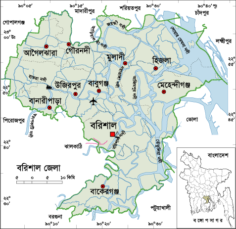
Barisal city Map, Bangladesh


Why is Barisal District Famous For?

Barisal has rich historical background. Barisal district is famous for its huge amount of agricultural products. Barisal is called the Agricultural Manchester of Bangladesh. Barisal is the leading district that allayed national vegetable demand. The legendary leader Sher-E-Bangla Fazlul Haque born in Barisal. Barisal river port is one of the busiest port in Bangladesh.


Famous Persons from Barisal District

Famous persons from Barisal District are- Birshresta Mohiuddin Jahangir, Ashini Klumar Datta (Politician), Major Abdul Jalil, Sashivhusan Das Gupta (Poet), Abdul Jabbar Khan (Singer), Humayun Kabir (Writer), Abdul Gaffar Chowdhury (Writer and Journalist), Abu Jafor Obaidullah (Writer and Poet), Asad Chowdhury (Poet), Sarder Fazlul Karim (Writer), Sufia Kamal (Poet), Adi Kobi Minnath, Monosha Mongol Poet Bijoy Gupta, Mukunda Das (Poet), Abdur rahaman Biswas (Politician), Shere Bangla A. K. Fazlul Hoque (Politician), Altaf Mahmud (Music Director), Jibananda Das (Poet), Kushum Kumari Das (Poet), Abdul Rob Sherniabat (Politician), Golam Mostafa (Actor), Subarna Mostafa (Actress), Papia Sarwar (singer), Rejowana Chowdhury Bannya (Singer), Amrita Lal Day (Writer), Mithun Chakroborti (Indian Hero), Rashed Khan Menon (Politician) etc.


Tourist Attractions in Barisal District

Brojomohan University College, Village of Sher-e-Bangla Chakher, Sher-e-Bangla Medical College, Durgasagor Lake, Oxford Mission Church, Ulania Royal Palace, Kittonkhola River, Subabad Fort, Shankor Temple, Jora Mosque, Sujabad Fort, Sangram Fort, Narikel Fort, Sher-e-Bangla Museum, The Bangabandhu Uddan (former Bell's Park), Shahid Abdur Rab Serniabat Bridge etc.


Barisal District, Bangladesh


Barisal District Bordered By-

Barisal District is bordered by MadaripurShariatpurChandpur and a part of Lakshmipur district to the north, PatuakhaliBarguna and Jhalokati Districts to the south, Bhola and Lakshmipur districts to the east, GopalganjPirojpur and Jhalokati districts to the west.


Barisal District Administrative data

The area of Barisal District is 2784.52 Sq Km. It is also a Divisional Headquarter. There is a city corporation; 05 Municipalities in Barisal named Mehidigonj, Bakergonj, Muladi, Banaripara and Gaurnadi. The number of Upazilla (sub district) in Barisal district is 10, named- Agailjhara, Gaurnadi, Babuganj, Bakerganj, Hizla, Mehendiganj, Barisal Sadar, Banaripara, Muladi and Wazirpur containing 85 Unions, 1001 Mauzas and 1116 Villages outside of metro area.


Barisal District Population Data

The total population of Barisal district is 23,34,203 (Male- 12,55,436 and Female- 13,14,935), Sex ratio 100:104, Population Density 946/Sq Km and annual growth rate is 0.78%. The Literacy Rate of Barisal district is 79.85%; school attendance rate is 86.60% for 5 to 24 years age group.


Other Important Data: The postal code of Barisal district is 8200 and NWD Code is 0431. Total Parliament seat in Barisal is 06. During the liberation war, Barisal was under Sector Number 08 & 09. Urbanization rate of the district is 22.33%. Annual rainfall of the region is 1955 mm.


Rivers in Barisal District

The main rivers flow through Barisal district are- Meghna, Ilisha, Kittonkhola, Arial-Kha, Tetulia, Biskhali, Hisla, Bakerganj, Kaligira, Kalabador, Lohania, Sandha, Ramgonj, Gojalia etc.


Agro Products from Barisal District

Barisal district is the national leading vegetable producer district. The main agro products from Barisal district are- Paddy, Jute, Sugarcane, Onion, Guava, Betel Leave, Mango, Jack fruit, Banana, Vegetables, Oil-seed etc.


Data Reference- Census Report-2022

About Bhola District, Bangladesh


About Bhola District, Bangladesh

Bhola is the largest and only one island district of Bangladesh located in the lower basin of Ganga River in the south- western part of Bangladesh. The island was formed in the estuary with the sediment carried by the three major rivers come down from Himalayan named Padma, Meghna and Brahmaputra. The region is average 12 feet above from the sea level. Approximately 1325 AD, the region was started to formed. According to Bakerganj Gazetier written by J C Jack, cultivation was started in the region in 1300 AD. In 1517 AD the island was occupied by a Portuguese pirate named John D. Silabera. The ancient name of the region was “south Shahbajpur”. There are not enough authentic documents about the naming of Bhola. Some historians think that Bhola was named after Bhola Gazi Patni, a boatman who ferried people in the formarly Betua River. During the East India Company period, Bhola sub-division was established in 1854 under Barisal district. It was upgraded to a district on 1 February 1984. Many people of the district, especially of Charfasson and Tazumuddin islands, lost their lives in a devastating cyclone and tidal bore in 1970.


Bhola District Map, Bangladesh


Why is Bhola District Famous For?

Bhola is the largest island of Bangladesh. Bhola district is famous for its very special buffalo curd which is unique in Bangladesh. There are about 55 buffalo baths in different island in Bhola. Bhola district is also famous for its fishing industry.


Famous Personalities from Bhola District

Famous personalitied from Bhola district are- Birshresta Mostafa Kamal, Tofayal Ahmed (Politician), Mozammel Hoque (Poet), Dr Abul Hasan Shamsuddin (Educationist), Firoza Begum (Educationist) Naziur Rahaman Monjur (Politician), Dr Azhar Uddin Ahmad (Politician), Major (Rtd) Hafiz Uddin Bir Bikrom (Politician), Comorad Nalini Das (Politician), Mosharof Hossain Shajahan (Politician), Nasir Ahmed (Poet), Principal Afsar Uddin Babul, Principal Faruquar Rahaman, A K M Makbul Ahmed (Poet), M. Mokammel Haque (Bureaucrate), etc.


Tourist attractions in Bhola District

Major Tourist attractions in Bhola district are- Monpura, Bhola Shishu Park, Birsresta Mostafa Kamal Museum, Kheaghat Bridge, Bhorhanuddin helipad, Shabazpur Gas Field, Monopura Island, Graveyard of Tofayel Shah, Kobi Mozammel Hoque Gateway etc.


Nature of Bhola District


Bhola District Bordered By-

Bhola District is bordered by Barisal and Lakshmipur district to the north, the Bay of Bengal to the south, Lakshmipur and Noakhali districts, the Meghna estuary and Shahbajpur Channel to the east, Patuakhali district and the Tetulia River to the west.


Bhola District Administration

The area of Bhola is 3403.48 Sq Km. It is under Barisal Division. There are 05 Municipalities in Bhola named Bhola, Charfashion, Borhanuddin, Daulatkhan and Lalmohon. The number of Upazilla (sub district) in Bhola district is 07, named- Bhola Sadar, Charfashion, Monopura, Lalmohon, Daulatkhan, Tazumaddin and Borhanuddin containing 68 Unions, 314 Mauzas and 438 Villages.


Bhola District Population Data

The total population of Bhola district is 19,32,518 (Male- 946,629 and Female- 985,815), sex ratio 99:100, population density 567.80/Sq Km and annual growth rate is 0.75%. The Literacy Rate of Bhola district is 67.30%, School attendance rate is 76.31% for 5 to 24 years age group.


Other Important Data: The postal code of Bhola district is 8300 and NWD Code is 0491. Total Parliament seat in Bhola is 04. During the liberation war, Bhola was under Sector Number 09. Urbanization rate of the district is 13.69%.


Rivers in Bhola District

The rivers that flow through Bhola district territory are- Meghna, Tetulia, Ilsha, Boalia, Shahbajpur channel etc.


Islands in Bhola District

The major island located in Bhola district are- Manpura, Dhalchar, Char Kukri-Mukri, Char Nizam, Char Jahiruddin etc.


Agro Products in Bhola District

The main agro products grow in  Bhola District are- Paddy, Jute, Potato, Onion, Garlic, Chilly, Peanuts, Mastered, Banana, Coconut, Betel Leaf, Betel Nut, Vegetables etc.


About Bogra District, Bangladesh


About Bogra District, Bangladesh

Bogra is an ancient district and the gateway to entrance in the northern part of Bangladesh. In the primitive history of mythology, Bogra has occupied an important role. The previous name of the region was “Pundabardhan”. The ancient capital of Pundra dynasty named Pundrabardhan is the current Bogra. During the 4Th to 12Th century the administrative centre point of the ancient dynasties of Maurja, Gupta, Paul, Sen etc were in the region. Bogra came under the Muslim rule when Ikhtiar Uddin Muhammad Bakhtiyar Khilji conquered Nadia in 1204. During 1279- 1282 AD, Sultan Nasiruddin Bagra Khan, the second son of Sultan Ghiyasuddin Balban who was the emperor of Delhi became the ruler of the region. Bogra was named after him. The anti British movement, Fakir-Sannyasi movement, the Indigo Rebellion etc are the remarkable chapters of the region. During the British East India Company period, Bogra district was established containing 9 police stations in 1821. After the liberation of Bangladesh, Bogra district was divided into two districts named Bogra and Joypurhat in 1983.


Bogra District Map, Bangladesh


Why is Bogra District Famous For?

Bogra district has rich historical background. Bogra was the capital city of ancient Pundranagar. Bogra is called the gateway of North Bengal. Bogra district is famous for Mahastangarh, one of the country's most valuable archaeological site. Bogra is also widely famous for its very special yogurts.


Famous Persons from Bogra District

Famous persons from Bogra District are-Major Ziaur Ziaur Rahaman( Politician), Noresh Chandra Sen Gupta, Bulbul Chowdhury, Akhtaruzzaman Ilias (Writer), Sadot Ali Akhondo (Literate Personality), Azizul Hoque (Poet), Enamul Hoque (Writer), Lutfar Rahaman Sarker, Sayad Anower Hossain, Chowdhury Mohammad Ali (Politician), Aminul Karim Dulal (Fine Artist), Anjuma Ara Begum (Singer), Khandaker Faruque Ahmed, Gaziul Hoque (Language Fighter), M. R. Akhter Mukul etc.


Tourist Attractions in Bogra District

The main tourist attractions in Bogra district are- Nawabbari, Kherua Mosque, Mohastangor, Shila Debir Hat, Behula – Luxindor er Bashor Ghor, Vasu Bihar, Bhabani Temple, Graveyard of Shah Sultan Balkhi (R), Bhabanipur Shib Mondir Kherua Mosque in Sherpur, Mohammad Ali Palace, Groan Barrage in Sariakandi, Wonderland etc.


Mohasthangarh, Bogra


Bogra District Bordered By-

Bogra District is bordered by Gaibandha and Joypurhat districts to the north, Sirajganj and Natore districts to the south, Jamalpur district and the Jamuna River to the east, Naogaon and Natore district to the west.


Bogra District Administration

The area of Bogra is 2898.68 Sq Km. It is under Rajshahi Division. There are 11 Municipalities in Bogra named Dhunat, Kahaloo, Santahar, Sherpur, Dhubchancia, Nandigram, Bogra, Shibganj, Gabtali, Sariakandi and Sonatala. The number of Upazilla (sub district) in Bogra district is 12, named- Bogra Sadar, Dhupchia, Adamdighi, Shibgonj, Dhunat, Shariakandi, Sonatola, Nondigram, Gabtali, Kahalu, Sherpur and Mazhira containing 110 Unions, 1613 Mauzas and 2618 Villages.


Bogra District Population Data

The total population of Bogra district is 37,34,297 (Male- 18,53,102 and Female- 18,80,861). Sex ratio is 100:101, population density 1288/Sq Km and annual growth rate is 0.83%. The Literacy Rate of Bogra district is 72.55%, School attendance rate is 79.69% for 5 to 24 years age group.


Other Important Data: The postal code of Bogra district is 6600 and NWD Code is 051. Total Parliament seat in Bogra is 07. During the liberation war, Bogra was under Sector Number 07. Urbanization rate of the district is 19.71%.


Rivers in Bogra-

The rivers flow through Bogra district are- Jamuna, Kartoa, Nagor, Bangali, Halhalia, Dakuria, Belai, Gazaria, Chandraboti, Manash, Iramoti, Velka etc.


Agro Products: Sugarcane, Tobacco, Paddy, Jute, Vegetables etc.


About Barguna District, Bangladesh


About Barguna District, Bangladesh

Barguna district is located in the south- western part of Bangladesh. Barguna district is average 11 feet above from sea level. There are not enough authentic documents about the naming of Barguna district. Some historians think that once timber traders of northern part came here to buy timbers and they waited for favoring flow (Baro- Gone) of the river of Khakdon to overcome and consequently the region was named Baro-Gona. By the passing of age, Baro- Gona muted to Barguna. Beside someone thinks that to dragging the boats against the mainstream of tide it was used “Gun.” So the region was named Barguna. Barguna police station was established in the last decade of the eighteenth century. It was upgraded into a sub-division in 1969 and finally the subdivision was turned into a district in 28 February 1984 after the liberation of Bangladesh. The Geo position of the district is between 21˚50’05’’ to 23˚04’10’’ North latitudes and between 89˚59’50’’ to 91˚04’08’’ east longitude.


Barguna District Map, Bangladesh


Why is Barguna District Famous For?

Barguna District specially famous for its fishing industry. the district is also famous for its agricultural products specially for coconuts and betel nuts.


Famous persons from Barguna District

Famous persons from Barguna district are- Prof. Sayad Fazlul Hoque, Shelina Hossain (Novelist), Motin Boiragi, Abdul Aziz Master, Dr Entaz Uddin, Delower Hossain Montu, Motiur Rahaman Talukder, Gazi Ali Ahmed etc.


Tourist Attractions in Barguna District

Tourist attractions in Barguna district are- Fatrar Char, Ashar Char, Haringhata Forest, Laldiar Char and Sea Beach, Mazhir Char, Sonbunia, Taltoli Rakhain Palli and Temple, Sonakata Forest, Donbunia, Mazhirchar, Khoyra Mosque, Samudra-Bilash, Bibichini Shahi Mosque etc.


Nature of Barguna district


Barguna District Bordered By-

Barguna District is bordered by JhalokatiBarisalPirojpur and a part of Patuakhali district to the north, Patuakhali district and the Bay of Bengal to the south, Patuakhali district to the east, Pirojpur and Bagerhat districts to the west.


Barguna district Administration

The area of Barguna is 1831.31 Sq Km. It is under Barisal Division. There are 04 Municipalities in Barguna named Barguna, Patharghata, Betagi and Amtoli. The number of Upazilla (sub district) in Barguna district is 05, named- Barguna, Patharghata, Bamna, Betagi and Amtoli containing 42 Unions, 259 Mauzas and 562 Villages.


Barguna District Population Data

The total population of Barguna district is 10,10,531 (Male- 494,738 and Female- 515,723), sex ratio 96:100, population density 551.80/Sq Km and annual growth rate is 1.10%. The Literacy Rate of Barguna district is 80.65%, School attendance rate is 89.10% for 5 to 24 years age group.


Rivers in Barguna District 

Rivers flow through Barguna district are- Haringhata, Biskhali, Dhaleswar, Adhar-Manik, Cheghai, Burishar, Khakdon, Rajgonj etc.


Agro Products from Barguna District 

Major agro products grown in Barguna district are- Rice, winter crops, peas, pepper, potatoes, pumpkin, watermelon etc.


Other Important Data: The postal code of Barguna district is 8700 and NWD Code is 0448. Total Parliament seat in Barguna is 02. During the liberation war, Barguna was under Sector Number 09. Urbanization rate of the district is 11.55%.


Thursday, December 26

About Brahmanbaria District, Bangladesh


About Brahmanbaria District, Bangladesh

Brahmanbaria district is located in the eastern part of Bangladesh. Once the region was a part of Samatat state. Later it was included in Tripura district in 1790. The first and temporary capital of Isa Khan was at Sarail, 10 km north of Brahmanbaria Town. Swadeshi movement (1905), Peasant movement (1930) No-rent movement, War of Liberation Movement (1971) etc are the remarkable chapters of the region. Brhamanbaria was promoted as a municipality in 1869. After the liberation of Bangladesh Current Brahmanbaria was declared as a district in 15 February 1984. Before, the region was included in Comilla district. The Geo position of the district is between 23˚29’ to 24˚16’ North latitudes and between 90˚39’ to 91˚21’ east longitude.


Brahmanbaria District Map, Bangladesh


Why is Brahmanbaria District Famous For?

Historically Brahmanbaria district was famous for 'Moslin' (Super fine thin cloth) in Mughal era. Now a days Brahmanbaria is famous for Chandramukhi Sweets (Milk based sweetmeat)


Famous Persons from Brahmanbaria District

Famous persons born in Brahmanbaria district are- Addyata Mollobormon (Novelist), Ostad Ayet Ali Kha (Musical Talent), Ostad Alauddin Kha (Musical Talent), Nawab Syed Shamsul Huda, Samaul Hoque (Poet), Ostad Khadem Hossain Kha (Music Personality), Haralal Roy (Writer), Ma Anyandamoye, Sayed Samsul Huda (Educationist), Oli Ahad (Language Fighter), Al Mahmud (Poet), Ali Imam (Literate Personality), Sayad Abdul Hadi (Singer), Safic Rehman (Editor), Subol Das (Composer), Alamgir (Film Actor), Abdul Kadir (Poet) etc.

Tourist attractions in Brahmanbaria District

Tourist attractions in brahmanbaria district are- Titas Gas Field, Graveyard of Birshresta Mostafa Kamal, Kasba Kollapathar Somadhi, Faruque Park, Graveyard of Kallishid (R), Home of Ostad Alauddin Kha, Hatirpul, Home of Biplobi Ullash Datta, Gonga Sagor, Meghna Bridge, Ashugonj Power Station, Jadughor Sahi Mosque, Haripur Landlord Palace etc.


Brahmanbaria District, Bangladesh


Brahmanbaria District Bordered By-

Brahmanbaria District is bordered by Kishoreganj and Habiganj district to the north, Comilla district to the south, Habiganj district and Tripura (Indian State) to the east, The Meghna River and a part of Kishoreganj, Narayanganj and Narsingdi districts to the west.


Brahmanbaria District Administration

The area of Brahmanbaria is 1881.20 Sq Km. It is under Chittagong Division. There are 04 Municipalities in Brahmanbaria named Brahamanbaria, Ashugonj, Nabinogor and Kasba. The number of Upazilla (sub district) in Brahmanbaria district is 09, named- Brahamanbaria, Akhaura, Kosba, Bangarampur, Sarail, Nabinagor, Nasirnogor, Ashugonj and Bijoy Nagor containing 100 Unions, 900 Mauzas and 1323 Villages.


Brahmanbaria District Population Data

The total population of Brahmanbaria district is 33,06,563 (Male- 15,38,262 and Female- 17,68,145), sex ratio is 93:100, population density 1758/Sq Km and annual growth rate is 1.40%. The Literacy Rate of Brahmanbaria district is 72.12%, School attendance rate is 77.39% for 5 to 24 years age group.


Rivers in Brahmanbaria

Rivers flow through Brahmanbaria district are- Meghna, Titas, Shalda, Hawra, Pagla, Putia, Sonai, Hawra, Ropa, Buri, Bizna, Balua, Bolak, Dholbanga etc.


Agro Products from Brahmanbaria

Agro products grow in plenty in Brahmanbaria District are- Paddy, Jute, Mastered, Onion, Garlic, Pulses, Pine-Apple, Vegetables etc.


Other Important Data: The postal code of Brahmanbaria district is 3500 and NWD Code is 0851. Total Parliament seat in Brahmanbaria is 06. During the liberation war, Brahmanbaria was under Sector Number 02 & 03. Average rainfall of the district is 78.06 cm urbanization rate of the district is 15.79%. Average rainfall of the region is 187 cm.


About Chandpur District, Bangladesh


About Chandpur District, Bangladesh

Chandpur district is located in the east central part of Bangladesh. According to the atlas of Major James Renal (1779), we found a minor region named Chandpur. Then government offices of the region were southern part of current Chandpur named Narasinghapur which is currently absorbed in river. The meeting place of mighty Padma and Meghna was then 60 miles southwest from the current location. During the Baro Bhuyan period, the region was under the rule of Chand Narayan Roy. Historian J F Sengupta thinks, Chandpur was named after him. Beside some historians think that Chandpur was named after Chand Fakir of Purindor Moholla (Current Koralia). In 1878, there were four sub divisions named- Sadar North, Sadar South, Brahmanbaria and Chandpur under Tripura district. After the liberation of Bangladesh, Chandpur subdivision was turned into a district in 1984. The area of Chandpur is 1645.32 Sq Km. The Geo position of the district is between 23˚29’ to 24˚04’ North latitudes and between 90˚06’ to 91˚09’ east longitude.


Chandpur District Map, Bangladesh


Why is Chandpur District Famous For?

One of the country largest fresh water fish harbor located in Chandpur, just beside the bank of Meghna River. Chandpur district is also famous for Chand Swadagor, a ligendary hero in folk tale.


Famous Persons in Chandpur District

Famous Persons born in Chandpur district are- Md Nasir Uddin, (Editor), Burhan Uddin Khan Jahangir (Literate Personality), Nawab Fayjun Nesa Chowdhurany, Hardayal Nag, Mohesh Chandra Vattacharja, Mohes Chandra Vattacharja, Dr Mizanur Rahaman Khan, Major Abdul Goni, Dr Akhter Hamid Khan, A K M Jahirul Hoque, Atindra Mohon Roy, Nawab Sir K G M Faruquee, Hem Prova Majumder, Captain Narendra Nath Datta, Dhrindra Nath Datta, Sachin Deb Barman, Basanta Kumar Majumder, Khan Bahadur Abdul Karim, Nawab Mosharof Hossain, Akhil Chandra Datta, Mohiuddin Khan Alamgir (Politician), Muntasir Mamun (Historian), Mizanur Rahaman Chowdhury (Politician), Samsul Arefin (Literate Personality), Nawab Sir Sayad Samsul Huda, Journalist Nasiruddin, Mawlana Abdul Mannan (Politician), Artist Hashem Khan, Moharaj Birchandra Manikka Bahadur, etc.


Tourist Attractions in Chandpur District

Tourist attractions in Chandpur district are- Chandpur River Port, River Research Institute, Mole head outfall in Barostation, Remnants of the Nasir Court fort, Baraduara, Historical Baro Mosque of Hazigonj, ICDDR,B in Motlob, Monoshamura, Meghna-Dhangoda Barrage, Nilkuthi, Sahsuja Mosque, Shah Rasti Dargah, Begum Mosque, Hajiganj Bara Mosque, Alamgiri Mosque, Mada Khan Mosque, Kali temple, Ilish Chattor, Lohagara ashram, Naorai ashram, Tultuli (Kachua) ashram, Rare species of plants Naglingam in DC Banglow etc.

Tin Nodir Mohona, Chandpur


Chandpur District Bordered By-

Chandpur District is bordered by Comilla and a part of Munshiganj district to the north, NoakhaliLakshmipur and Barisal districts to the south, Comilla district to the east, Shariatpur, Munshiganj districts and mighty Meghna River to the west.


Chandpur District Administration

It is under Chittagong Division. There are 07 Municipalities in Chandpur named Chandpur, Hazigonj, Faridgonj, Kachua, Motlob, Chengar-char and Shaharasti. The number of Upazilla (sub district) in Chandpur district is 08, named- Chandpur, Motlob North, Motlob South, Haymchar, Hazigonj, Kachua, Shaharasti and Faridgonj containing 88 Unions, 927 Mauzas and 1230 Villages.


Chandpur District Population Data

The total population of Chandpur district is 27,13,247 (Male- 12,29,413 and Female- 14,06,255). Sex ratio is 92:100, population density 1649/Sq Km and annual growth rate is 0.618%. The Literacy Rate of Chandpur district is 78.23%, School attendance rate is 86.80% for 5 to 24 years age group.


Rivers in Chandpur District

Chandpur town is divided by mighty Dakatia River. Besides Meghna, Dhonagoda, Motlab, Udhamdi etc are the mentionable rivers in Chandpur.


Agro Products from Chandpur

Agro products grown plenty in Chandpur district are- Paddy, jute, wheat, sugarcane, potato, mustard, betel nut, soybean, pepper, vegetables etc.

Other Important Data: The postal code of Chandpur district is 3600 and NWD Code is 0841. Total Parliament seat in Chandpur is 05. During the liberation war, Chandpur was under Sector Number 02. Urbanization rate of the district is 18.03%.

About Chapainawabganj District, Bangladesh


About Chapainawabganj District, Bangladesh

Chapainawabganj district is located in the western border of Bangladesh. According to geographical formation the district is divided into two parts named Barendra region located in the eastern part of the Mohanoda River and Diar region located in the western part of the same river. Until 1947, Chapainawabganj was a police station under the district of Maldah (India). At the time of partition in 1947, it was upgraded into a Subdivision under Rajshahi district. After the liberation of Bangladesh the region was finally upgraded into a district in 1984. The Geo position of the district is between 24˚22’ to 24˚57’ North latitudes and between 87˚55’ to 88˚23’ east longitude. Chapai Nawabganj district is famous for its mangoes that are greatly delicious.


Chapainawabganj District Map, Bangladesh


Why Chapainawabganj District Famous For?

Chapainawabganj District has rich historical background. The district is famous for huge amount of fine quality mango production. The district is called the mango capital of Bangladesh.


Famous Persons from Chapainawabganj District

Famous persons born in Chapainawabganj district are- Diantullah Chowdhury (Hero of Indigo Resistance Movement), Birsresta Captain Mohiuddin Jahangir, Girish Chandra Singha (Land Lord), Prof. Abdur Rahim (Mathematician), Kutub Uddin (Pioneer of Gamvhira), Sayad Ali Ashraf, Sahabuddin Nagori (Singer), Momtaz Uddin Ahmad (Writer and Play Personality), Abdul Hoque, Rafiqunnabi (Artist), Prof. Moniruzzaman Mia, Justice Mainur Reza Chowdhury etc.


Tourist Attractions in Chapainawabganj District

Tourist attractions in Chapainawabganj district are- Choto Sona Mosque, Rajshadin Gaur of Bokhtier Khalgi, Graveyard and Mango Orchard of Shah Neamot Ullah, Landscape of Babu Dying, Kanchat Rajbari, Sah Suja Hambolkhana, Nowda Tomb, Darsbari, Shibmondir and couple of Temp in Huzabpur, Darashbari Mosque, Royal palace, Baragharia Kacharibari (Revenue Office), Chapai Mosque, Naoda Stupa (Buddhist monument), Nachole Palace, Graveyard of Birsresta Captain Mohiuddin Jahangir, Adina College and Idrishi Bhaban etc.


Chapainawabganj District, Bangladesh


Chapainawabganj District Bordered By-

Chapainawabganj District is bordered by Maldah district of West Bengal (Indian State) to the north, the mighty Padma River and Murshidabad district of West Bengal (Indian State) to the South, Rajshahi and Naogaon districts to the east, the Padma River and Maldah district of west Bengal to the West.


Chapainawabganj District Administration

The area of Chapainawabganj is 1702.55 Sq Km. It is under Rajshahi Division. There are 04 Municipalities in Chapainawabganj named Chapainababganj, Shibgonj, Rohonpur and Nachole. The number of Upazilla (sub district) in Chapai Nawabganj district is 05, named- Chapainababganj, Shibgonj, Nachole, Gomastapur and Volahat containing 45 Unions, 619 Mauzas and 1135 Villages.


Chapainawabganj District Population Data

The total population of Chapainawabganj district is 18,75,290 (Male- 887,170 and Female- 948,282). Sex ratio is 97:100, Population Density 1101/Sq Km and annual growth rate is 0.80%. The Literacy Rate of Chapainawabganj district is 66%, School attendance rate is 73.80% for 5 to 24 years age group.


Rivers in Chapainawabganj District

Rivers flow through Chapainawabganj district are- Padma, Mohanonda, Punarbhaba, Tangon, Maragada, Pagla, Nondaguja etc.


Agro Products from Chapainawabganj District

Mango, Guava, Jack-Fruit, Water Melon, Maize, Litchi, Oil seeds Paddy, jute, sugarcane, wheat, Betel Leaf, pulses, guava, Palm etc


Other Important Data: The postal code of Chapai Nawabganj district is 5280 and NWD Code is 0781. Total Parliament seat in Chapai Nawabganj is 03. During the liberation war, Chapai Nawabganj was under Sector Number 07. Urbanization rate of the district is 19.44%. Average rainfall of the region is 186 cm.


About Chattogram Port City, Bangladesh


About Chattogram Port City, Bangladesh

Chattogram port city located in the south- eastern part of Bangladesh. Chittagong had been a sea port since the ancient time. Traders from different countries including Arab had business transactions with this port since 9Th century. Sultan Fakruddin Mubarak Shah of Sonargaon conquered Chittagong in 1340. After the defeat of Sultan Giasuddin Mahmud Shah by Sher Shah in 1538 AD, the Arakanise again captured Chattogram city. The region was under the kingdom of Arakan during sixth and seventh centuries. During 17Th century the region faced many attacks of Portuguese pirates. Before the Muslim conquered, Chattogram had been either under the control of the Arakans or under the kings of Burma. The Mughal Commander Bujurg Umed Khan expelled the Portuguese pirates from the region and eastablished Chittagong district in 1666 and named Islamabad. Next the region was named Chattla and Chandgaon and now Chattogram. The Chittagong Hill- Tracts were separated from Chittagong in 1860. Cox’s Bazar was separated from Chattogram district in 1984 after the liberation of Bangladesh.


Chattogram District Map, Bangladesh


Why is Chattogram district famous for?

Chattogram district is famous for rich biodiversity and natural beauty. Chattogram district has rich historical background and has strong cultural diversification. Chittagong Sea Port also located in the southern part of Chattogram City which is the main lifeline of Bangladeshi import-export. Chattogram sea port is the 67th busiest port (2023) considering container handling. 


Famous Persons from Chottogram District

Famous persons born in Chattogram are- Masterda Surjasen, Priti Lota Owadder, Abdul Karim Sahittobisharod, Principal Abul Quashem (Educationist), Koreshi Magon Thagure, Mohakobi Alaol, Kalpana Datta, Sayad Owali Ullah (Novelist), Binodbihari Chowdhury, Jahur Ahmad Chowdhury, M A Hannan, M A Aziz, Subrder Rajab Ali (Hero of Shipahi Revoloution), Kajem Ali Master, Comorad Mozaffor Ahmad, Jatindra Mohon Sen, Martyred Nirmol Sen, Amibca Chattargy, Gonesh Ghosh, Abdul Hoque Dovas, Rafiq Uddin Shiddique, Brozen Sen, Sharat Kanungo, Kalipod Chattargy, Prof. Pulin Day, Amor Sen, Comored Abdus Satter, A K Khan, Chowdhury Harunur Rashid, Captain Abul Quashem, Shirajul Hoque Mia, Khanbahadur, Natun Chandra Shingha, Probal Chowdhury, Sujat Roy, Ayub Bacchu, Nakib Khan, Roby Chowdhury, Partha Barua Dr Keshob Sen, Dr Harihar Datta, Jotirmoye Chowdhury, Kabial Romesh Shil, Shah Muhammad Sagir (Poet) etc.


Top Tourist Attractions in Chattogram City

Top tourist attractions in Chattogram city are- Fays Lake, Potenga Sea Beach, Chittagong Zoo, Chittagong University, Graveyard of Bayajid Bostami, Graveyard of Shah Amanat, War Cemetery, Zia Memorial Museum, Asian Women University, Fauzdarhat Cadet College, Mahuri Project, Batali Hill, Chandranath Hill of Shitakunda, Hot Water Fall, Bashkhali Eco Park, Parky Sea Beach in Anowara, Bangladesh Military Academy, Marine Academy etc.


Chittagong District, Bangladesh


Chattogram District Bordered By-

Chittagong District is bordered by Feni district and Tripura (Indian State) to the north, Cox’s Bazar district to the south, RangamatiBandarban and Khagrachari districts to the east, Noakhali district and the Bay of Bengal to the west.


Chattogram District Administration

The area of Chattogram is 5282.92 Sq Km. It is a divisional Headquarter also. There is a city corporation; 10 Municipalities in Chittagong named Chandanaish, Banskhali, Baroiarhat, Sandwip, Mirsharai, Rangunia, Satkania, Raozan, Patya and Shitakunda. The number of Upazilla (sub district) in Chittagong district is 14, named- Mirsarai, Shitakunda, Raujan, Sandwip, Rangunia, Fatikchari, Hatahazari, Patya, Anowara, Chandanaish, Boalkhali, Bashkhli, Lohagora and Satkania containing 194 Unions, 890 Mauzas and 1267 Villages outside of metro area.


Chattogram District Population Data

The total population of Chattogram district is 94,39,076 (Male- 45,70,113 and Female- 45,98,926), Sex ratio 99:100, Population Density 1787/Sq Km and annual growth rate is 1.60%. The Literacy Rate of Chittagong district is 81.06%, School attendance rate is 89.31% for 5 to 24 years age group. Literacy rate is above average in Chattogram city.


Other Important Data: The postal code of Chittagong district is 4000 and NWD Code is 031. Total Parliament seat in Chittagong is 16. During the liberation war, Chittagong was under Sector Number 01. Urbanization rate of the district is 41.39%, average rainfall is 3378 mm average moisture is 83%.


About Chuadanga District, Bangladesh


About Chuadanga District, Bangladesh

Chuadanga is the south- western borderline district of Bangladesh. The previous name of the region was “Gangaridhi.” It is thought from the records of the Greek historians and geographical formations of the region that it was a part of the kingdom of Gangaridhi and there was a city called Gangey in the region. In the British East India period, Chuadanga along with Kushtia region was a under Rajshahi district. Then the region was included with Pabana district in 1828. In the time of partition in 1947, excepting Krishnagar police station, the whole territory of Chuadanga sub-division was included in Kushtia district. The Wahabi Movement (1831), Faraizi Movement (1838-47), Sepoy Revolt (1857), Indigo Rebellion (1859-60), Khilafat Movement (1920), Swadeshi Movement (1906), Non Cooperation Movement, Violation of Law Movements (1920-40), Quit India Movement, August Revolt (1942) etc are the remarkable chapters of the region. After the liberation of Bangladesh, Chuadanga was turned into a district on 16 February 1984. The one and only Alcohol production factory of Bangladesh named Keru and Company located in the region.


Chuadanga District Map, Bangladesh


Why Chuadanga District Famous For?

Chuadanga district has strong historical heritage. Chuadanga is a food surplus district. i e Chuadanga district is famous for huge agricultural products. Chuadanga district is specially famous for Keru and Company, the one and only Alcohol producer in Bangladesh.


Famous Persons from Chuadanga District

Famous persons born in Chuadanga district are- Atul Kridna Saha (Leader of the Movement against British), Ananta Hari Mitra, Amia Kumar Roy, Advocate Younous Ali, Islam Uddin Malik, Moslem Ali Biswas (Journalist), Janki Nath Ghosal, Sarnakumari Debi, Sreehori Roy, Akram Ahmed (Bir-Uttam), Sree Hori Roy (Leader of Nil Rebellion) Kali Proshanna Chattergy (Editor), Dr Radha Binod Paul, Solaiman Haq Jowarder (Selun), Mr. Ali Ajgor (Togor) etc.


Tourist Attractions in Chuadanga District

Tourist attractions in Chuadanga district are- Ershad Baag and Fisheries, Dingedah Bazar, Alamdanga Rail-Way Station, Dorshana Rail-Way Station, Mazar of Khaza Malik-ul-Gaus (R), Dingedaha Meteri Fair, Goruy Tipy, Three domed Chuadanga Bôro Mosque, Gholdari Mosque, Chuadanga Circuit House, Natudah Atkabar, Hajar Duari School (Damuŗhuda), Karpashdaņa Neelkuţi, Gholdari Neelkuti, Karew and Company etc.

Rabindra Kuthibari, Chuadanga


Chuadanga District Bordered By-

Chuadanga District is bordered by Kushtia district to the northeast, Jhenaidah district to the southeast, Meherpur district to the northwest and Nadia district of West Bengal (Indian State) to the southwest.


Chuadanga District Administration

The area of Chuadanga is 1174.10 Sq Km. It is under Khulna Division. There are 04 Municipalities in Chuadanga named Chuadanga, Alamdanga, Damurhuda and Jibonnagor. The number of Upazilla (sub district) in Chuadanga district is 04, named- Chuadanga, Alamdanga, Damurhuda and Jibonnagor containing 32 Unions, 345 Mauzas and 521 Villages.


Chuadanga District Population Data

The total population of Chuadanga district is 12,34,054 (Male- 607,636 and Female- 626,355), Sex ratio 99:100, Population Density 1051/Sq Km and annual growth rate is 0.79%. The Literacy Rate of Chuadanga district is 71.20%, School attendance rate is 76.89% for 5 to 24 years age group.


Rivers in Chuadanga

Rivers flow through Chuadanga are- Naboganga, Mathavanga, Vairab, Kumar, Chitra etc.


Agro Products: Paddy, Jute, Sugarcane, Betel Leaf etc.


Other Important Data: The postal code of Chuadanga district is 9000 and NWD Code is 0761. Total Parliament seat in Chuadanga is 02. During the liberation war, Chuadanga was under Sector Number 08. Average rainfall of Chudanga district is 1467 mm and Urbanization rate is 27.12%.


Tuesday, December 24

About Comilla District, Bangladesh


About Comilla District, Bangladesh

Comilla district is located in the south eastern part of Bangladesh. The naming of Comilla is debatable by historians. But among the current opinions fairly acceptable opinion found in the travel Writing of Chainik traveler “Wang Choang” when he traveled the Samtat state. In his description we found a name “Kiamolonkia” that turned into Comilla. A large portion of historians accept the opinion. The Comilla region was once under the ancient Samatat state and next included in Tripura State. This district came under the rule of the kings of the Harikela in the ninth century. Lalmai and Mainamati were once ruled by Deva dynasty (18Th century) and Chandra dynasty (during 10Th and up to mid of eleventh century). It came under the rule of East India Company in 1765. This district was established as Tripura district in 1790. Peasants Movement (1764), Anti Partition Movement (1905), Mass Movement (1969) etc are the notable chapters of the region. In the Pakistan Period, the region was renamed Comilla in 1960. Chandpur and Brahmanbaria subdivisions were then included in Comilla District. The Geo position of the district is between 23˚01’ to 24˚11’ North latitudes and between 90˚34’ to 91˚22’ east longitude.


Comilla District Map, Bangladesh


Why is Comilla District Famous For?

Comilla District has historical rich background. Currently the district is famous for 'Khadi Kapor' and 'Matri Vandar Rosmalai' (milk based sweetmeat).


Famous Persons from Comilla District

Famous persons from Comilla District are- Prof. Mozaffor Ahmad, Dhrindra Nath Datta (Politician), A. T. M. Samsul Hoque (Politician), Khondaker Mostaq Ahmad (Ex-president), Azit Kumar guha (Writer), Anis Chowdhury (Writer), Nawab Fayjunnessa Chowdhury, Buddhyadeb Basu (Novelist), Sachin Deb Barman (Singer, composer & music director), Sursagor Himanshu Dutta, Abul Khyer Muslehuddin (Writer), Monayem Sarker (Politician), Mobasher Ali (Literate Personality), Abdul Kadir (Poet), Moteher Hossain Chowdhury (Writer), Gias Kamal Chowdhury (Journalist), Basonta Kumar Majumder, Yousouf Abdullah Harun (Politician and Business Personality), Dr. Zobaida Hannan, Mahasthabir Shilvadra (great Buddhist monk & pandit), M.K. Anwar (Ex-minister), Shib Narayan Das (Freedom Fighter), Air Vice-Marshall Mohammad Jamaluddin (ex-Chief of Staff of Bangladesh Air Force),Barrister Shafiq Ahmed (Politician), Advocate Abdul Motin Khosru, Kailashchandra singha (Historian), Mohamed Ali Azam (Educationist) etc.


Tourist Attractions in Comilla District

Tourist Attractions in Comilla district are- Kort-Bari, BARD, Moynamoti, Lalmay Hill, Shalbon Amorous Diversion, Second World War cemetery, Meghna-Gomoti Bridge, Bakhrabad Gas Field, Dhormosagor, Jagannath Bari Temple and Lake, Lateshor Lake, Core of Buddhist Civilization, Pashchimgaon Nawab Bari, Victoria College, Comilla Zilla School, Kutila Mura, Charandra Mura, Rupban Mura, Itakhola Mura, Satera Ratna Mura, Ranir Banglar Pahar, Ananda Bazar Palaces, palaces of Bhoj King, Shah Suja Mosque, Chandimata Mandir, Chandala Shiva Mandir, Mazars of Panch Pir (Five Saints), Harimangal Math, Ramnagar elongated Math, Saitshala Rammahan Mandir, Hasnabad Math, Town Hall Memorial etc.


Comilla District, Bangladesh


Comilla District Bordered By-

Comilla District is bordered by Narayanganj and Brahmanbaria district to the north, Noakhali and Feni district to the south, Tripura (Indian State) to the east, Chandpur and a part of Munshiganj district to the west.


Comilla District Administration

The area of Comilla is 3146.30 Sq Km. It is under Chittagong Division. There are 10 Municipalities in Comilla named Baruna, Chauddagram, Homna, Comilla, Comilla Dakkhin, Nangalkot, Chandina, Daudkandi, Debidawar and Laksham. The number of Upazilla (sub district) in Comilla district is 16, named- Comilla Sadar, Homna, Laksham, Muradnagor, Debidar, Barura, Daudkandi, Burichong, Chandina, Chaddagram, Nagolcot, Bhrammonpara, Meghna, Titas, Monohorgonj and Sadar Dokkhin containing 185 Unions, 2455 Mauzas and 3532 Villages.


Comilla District Population Data

The total population of Comilla district is 62,12,216 (Male- 29,00,371 and Female- 33,11,580). Sex ratio is 92:100, population density 1974/Sq Km and annual growth rate is 1.30%. The Literacy Rate of Comilla district is 76.68%, school attendance rate is 88.90% for 5 to 24 years age group.


Rivers in Comilla District

Rivers flow through comilla district are- Meghna, Gomati, Titas, Dakatia, Kakri etc.


Agro Products from Comilla District

Major agro products grow in Comilla district are- Paddy, Jute, Wheat, Chilly, Onion, Garlic, Peanuts, Sugarcane, Yam, vegetables, Oilseed etc.


Other Important Data: The postal code of Comilla district is 3500 and NWD Code is 081. Total Parliament seat in Comilla is 11. During the liberation war, Comilla was under Sector Number 02. Urbanization rate of the district is 15.60%.


About Cox's Bazar District, Bangladesh


About Cox's Bazar District, Bangladesh

Cox's Bazar is a coastal district located in the south- eastern part of Bangladesh. The Arab traders and preachers came to the ports of Chittagong and Akiab in the eighth century AD and consequently the Arab Muslims came in close contact with Cox's Bazar area located between the two ports. The greater Chittagong including Cox's Bazar was under the rule of Harikela king Kantideva in the 19Th century. The Arakan king Sulat Inga Chandra (930-975) captured Chittagong in 953 AD and since then Cox's Bazar had been a part of the kingdom of Arakan. Chittagong remained part of the kingdom of Arakan till it is conquered by the Mughals general Buzurag Umed Khan in 1666 AD captured the Magh Fort on the southern part of the Karnafuli and the Arakanise then took shelter in the Ramu Fort. The ancient name of the region was “Palking”. The current Cox’s Bazar was named after Captain Hiram Cox’s who conquer the region in the British East India Company period and set up a bazar that is called the bazar of Cox’s Shaheb by civilians. By the passing of age the region was named as Cox’s Bazar. The Geo position of the district is between 20˚35’ to 21˚50’ North latitudes and 91˚23’ east longitude. Current Cox’s Bazar district is formed in 1984. Before it was a part of Chittagong district.


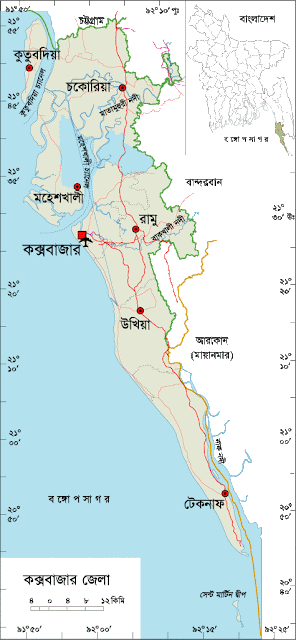
Cox's Bazar District Map, Bangladesh


Why is Cox's Bazar famous for?

Cox's bazar mostly famous for its world longest natural sandy sea beach. It is not the end, Cox's bazar is also so famous for its beach based hospitality, sea foods, marine drive, Moheskhali and Saint Martins island.  


Famous Persons from Cox's Bazar District

Famous persons born in Cox's Bazar district are- Sahid Saber, Nurul Huda (Poet), Dr Sahajahan Munir (Literate Personality), Abdur Rashid Shiddique, Prof. Samser Uddin Chowdhury, Muhammad Nurul Huda (Poet), Mohammad Mostak Ahmad Chowdhury (Politician), Dula Fakir(Saiant), Hazrat Alauddin Shah (Saint), Ostad Abu Bakar (Cultural Personality) etc.


Tourist Attractions in Cox's Bazar

Tourist attractions in Cox's Bazar are- Cox’s Bazar Sea Beach, Teknaf, Saint Martin Island, Moheskhali, Adinath Temple, Sonadia Island, Buddhist Murti of Ramu, Himchari, Inane Beach, Kutubdia Light House, Aggmeda Khyang (a large Buddhist monastery), Ram Court, Bangabandhu Safari Park etc.

Cox's Bazar Sea Beach, Bangladesh


Cox's Bazar District Bordered By-

Cox’s Bazar District is bordered by Chittagong district to the north, the Bay of Bangal to the south, Bandarban district, the Naf River and Arakan (a state of Myanmar) to the east, the Bay of Bengal to the west.


Cox's Bazar District Administration

The area of Cox’s Bazar is 2491.85 Sq Km. It is under Chittagong Division. There are 04 Municipalities in Cox’s Bazar named Cox’s Bazar, Chakoria, Teknaf and Moheskhali. The number of Upazilla (sub district) in Cox’s Bazar district is 08, named- Cox’s Bazar Sadar, Moheskhali, Chakoria, Kutubdia, Ramu, Ukhya, Teknaf and Pakua containing 71 Unions, 177 Mauzas and 989 Villages.


Cox's Bazar District Population Data

The total population of Cox’s Bazar district is 29,06,281 (Male- 14,34,622 and Female- 13,88,563). Sex ratio is 104:100, Population Density 1166/Sq Km and annual growth rate is 1.80%. The Literacy Rate of Cox’s Bazar district is 71.58%, School attendance rate is 76.49% for 5 to 24 years age group.


Rivers in Cox's Bazar

Remarkable rivers flow through Cox's Bazar named- Naf, Matamuhari, Bakkhali, Reju Khal, Naf River, Maheshkhali channel, Kutubdia channel etc.


Agro Products in Cox's Bazar District

Agro based products grows in Cox's Bazar plenty are- Paddy, Jute, Rubber, Coconut, Batel Nut, Marine Fish, dry fish etc.


Major Islands in Cox's Bazar

Major island located in Cox's bazar named- Moheskhali, Kuubdia, Sonadia, Saint-Martin etc.


Other Important Data: The postal code of Cox’s Bazar district is 4700 and NWD Code is 0341. Total Parliament seat in Cox’s Bazar is 04. During the liberation war, Cox’s Bazar was under Sector Number 01. Urbanization rate of the district is 21.79%. Average rainfall of the district is 3378 mm and average moisture is 83%.


About the Capital city of Bangladesh, Dhaka


About the Capital City of Bangladesh, Dhaka

Capital city Dhaka district is located in the central part of Bangladesh. The city has rich historical background. In 1971, when Bangladesh achieved her independence, Dhaka is adorned as the capital of newly borned country. The area of Dhaka district is 1,683.27 Sq Km. Its Geo location is 23˚22’30’’ to 24˚22’20’’ North latitudes and 89˚41'6'' to 90˚59'23'' east longitude. Dhaka is one of the most population dense mega city in the world.


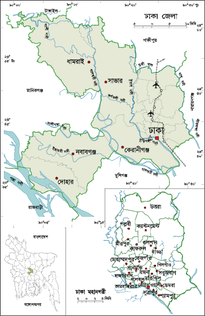
Dhaka City Map, Bangladesh


History of Dhaka City

History of Dhaka city is very rich. There is no enough evidence about the origin of the name of Dhaka. Some of the common opinions are as follows: a) the area is covered with a lot of Diaper phudosa trees, b) On the day of the inauguration of the mayor of the capital, drum was playing on the order of Islam Kha, c) a commonplace language named ‘Dhakabhasa' was very common in the region, d) Dhacca is mentioned as an Observatory center in Rajtarangi. Mr Jowao-d-Barrows mentioned the region as an important place at his atlas. In 1610 Islam Khan, the commander of Mughal ruler transferred the capital from Rajamahal to Dacca and named after the emperor Jahangirnagar. In the pre- Mughal era Dacca was a local trade center because of the location of riverside. It was a rich production Center also. The cotton based fabrics named Muslin was then very popular around the world. It was exported a high volume and for the Muslin fabrics, European Companies paid a high quantity of Gold and Silver. In 1829 Dacca was adorned as a large divisional Headquarter and around 1885 Dhaka was built the largest civilian center after Calcutta. During 1905-1911, the importance of Dacca dramatically increased when it was declared as the Capital of the province of newly formed East Bengal and Assam administration. In 1947, the end of British colonial rule and the establishment of an independent state of Pakistan in the name of the new province of East Pakistan, the region became more stable. 


Why is Dhaka city famous for?

Dhaka, the capital city of Bangladesh has historical heritage in this region. Dhaka city is famous for rickshaw, culture and religious diversification. Dhaka is called the city of Mosques. Dhaka is also famous for its huge variations of street food.


Famous Persons from Dhaka District

Famous persons born in Dhaka are- Nawab Sir Salimullah (Social Worker & Land Lord), Atul Proshad Sen (Poet), Nawab Abdul Goni (Land Lord), Nawab Ahsan Ullah(Land Lord), Kaykobad (Poet), Khaja Nazimuddin (Politician), Ranada Proshad Saha, Samar Das(Singer), Kali Prosanna Shingha, Dr. Anisuzzaman (Educationist), Vi Girish Chandra Sen, Khaja Abdul Goni etc.


Top Tourist Attractions in Dhaka city

Top tourist attractions in Dhaka city are- National Memorial, Dhaka University, Bangladesh-China Friendship Conference Center, Dakeshari temple, Lalbag Fort, Ahsan Monjil, Aorangajeb Fort, Jinjira Palace, Baro Katara, Choto Katara, National Museum, Mirpur Zoo, Kamalapur Railway Station, Ramna Park, Sohrawardi Park, TSC, Sahajalal International Airport, Botanical Garden, Central Sahid Minar, Satmosjid, Bangabandhu Memorial Museum, The Parliament House, Karjon Hall, Bahadur Shah Park, Bibi Morium Canon, Hosni Dalan, Ruplal House, Graveyard of Three Renouned Leader, Bangla Academy, Martyred Graveyard of Mirpur, Rose Garden, Lalkuthi, Chamely House, Baitul Mokaram Mosque, Tara Mosque, Binot Bibi Mosque, Shatgambuj Mosque, Dhakeshari Temple, Armenian Church, Novo Theatre, Muktijuddha Museum, Science and Technology Museum, Shilpakala Academy, Nazrul Academy etc.

Dhaka city, Bangladesh


Dhaka city Bordered By-

Dhaka city is bordered by Gazipur and Tangail district to the North, Rajbari and Munshiganj districts to the South, Narayanganj district to the East and Manikganj district to the West.


Dhaka District Administration

Dhaka City Corporation is now divided into two part named Dhaka north and Dhaka South City Corporation and 03 municipality outside of city area. It has 05 upazilla (sub-district) named Dhamrai, Dohar, Keranigonj, Nawabgonj and Saver outside of metro area. The mentioned sub- districts contain 79 unions Parishad, and 1863 village.


Dhaka City Population Data

The last known population of Dhaka district is 1,47,34,701, sex ratio 119:100, Population density 10,067/Sq Km, annual growth rate 1.80%. Literacy Rate is 84.88% and School attendance rate is 89.39% for 5 to 24 years old.


Rivers in Dhaka District

Rivers flow through Dhaka district are- Burigonga, Dhaleshari, Shitalakha, Bongshi, Turag, Eshamoti, Balu-Nadi etc.


Other Important Data: The post code of Dhaka is 1000 (GPO) and 1100 for Dhaka Sadar Post office. NWD code – 02 and total parliament seats are 20. In the liberation war period Dhaka was under Sector No 02.


Data Ref: Census Reprot-2022

8088218514