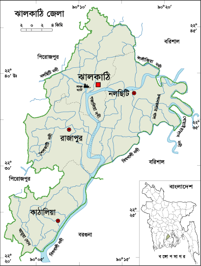
About Jhalokati District, Bangladesh
Jhalokati is a small district located in the southern coastal part of Bangladesh. Jhalokati subdivision was established in 1972 and was turned into a district in 1984 after the liberation of Bangladesh. The Geo position of the district is between 22˚25’ to 22˚49’ North latitudes and between 90˚58’ to 90˚18’ east longitude. Jhalokati is the residence of the maternal uncle of great poet Jibonanondo Das.
History of Jhalokati District
It is not sure when the first human habitation introduced in the region but it is to be understood from the name that Kaibarta fishermen first introduced planting in the region in the most ancient period. Kaibarta fishermen were called Jhalo and their residential place was called Jhalopara. Most of the historians think that the name Jhalokati came from the word Jhalopara. Most of the people of then Jhalokati river port were Kaibarta that means fishermen.
The ancient name of the region was “Moharajganj.” Jhalokati was once called the “Second Calcatta” because of its commercial importance. The communication facilities of the region attracted the merchants of East India Company, Dutch, French etc and they established their trade centers in the region.
Jhalokati District Bordered By-
Jhalokati District is bordered by Barisal district to the north, Barguna district and the Biskhali River to the south, Barisal and Patuakhali district to the east and Pirojpur district to the west.
How many Thana and Union in Jhalokati District?
The area of Jhalokati is 706.76 Sq Km. It is under Barisal Division. There are two Municipalities in Jhalokati named Jhalokathi and Nalchiti. The number of Upazilla (sub district) in Jhalokati district is 04, named- Jhalokathi Sadar, Nalchiti, Rajapur and Kathalia containing 32 Unions, 395 Mauzas and 455 Villages.
Why is Jhalokati District Famous For?
Jhalokati district historically famous for salt industry. Jhalokati also famous for betel leaves production. Jhalokati was famous for its rivers network. As a result, Dutch and East India Company open trade center in this region.
Famous persons from Jhalokati District
Kamini Roy (Poet), Santos Gupta, Abdul Goni Boyati, Shashanka Paul (Writer), Mawlana Mohammad Azizur Rahaman (Religious Personalities), Abdul Hashem Boyati etc.
Tourist Attractions in Jhalokati District
Tourist attractions in Jhalokati district are- Suja Badsha Fort, Rajapur Saturia Royal Palace, Kirtipasha Royal Palace, Shidda Kathi Royal Palace, the residence of the maternal uncle of great poet Jibonanondo Das, Residence of Kamini Roy, Gabkhan Bridge, Dhansiri River, Galua Mosque, Nesarabad Complex, Ponabalia Temple, etc.
Jhalokati District Population Data
The total population of Jhalokati district is 661,160 (Male- 329,147 and Female- 353,522), sex ratio 93:100, population density 935.50/Sq Km and annual growth rate is (-) 0.28%. The Literacy Rate of Jhalokati district is 83.21%, School attendance rate is 89.30% for 5 to 24 years age group.
Rivers in Jhalokati district
Rivers flow through Jhalokati district are- Biskhali, Sugondha, Gajalia, Khyara, Dhansiri etc.
Agro Products from Jhalokati district
Agro products grow in plenty in Jhalokati district are- Paddy, Jute, Sugarcane, Banana, Pulse, Vegetables etc.
Other Improtant Data: The postal code of Jhalokati district is 8400 and NWD Code is 0498. Total Parliament seat in Jhalokati is 02. During the liberation war, Jhalokati was under Sector Number 09. Urbanization rate of the district is 16.41%.


No comments:
Post a Comment
Thanks for commenting my blog. Your comment will publish very soon.