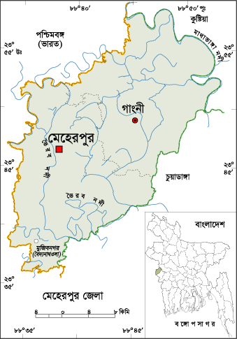
About Meherpur District, Bangladesh
Meherpur is one of the western borderline districts of Bangladesh. There is about 60 Km international borderline in Meherpur. During the beginning of liberation war of Bangladesh, the first provisional government of Bangladesh took oath here (Voberpara, Baiddyanathtola) on 17 April 1971. The Geo position of the district is between 23˚44’ to 23˚59’ North latitudes and between 88˚34’ to 88˚53’ east longitude
History of Meherpur District
There are not enough authentic documents about the naming of Meherpur. Two estimates are found in reliable documents about the naming. First- Meherpur was named after Saint Meher Ali in 16Th century. Second- Bachanker (poet) Mihir Ali and his daughter in law “Khona” lived in the region and Mihirpur was named after Mihir Ali. The word “Mihirpur” convert to Meherpur by the passing of age.
Meherpur was adorned as a subdivision in 1854 or 1857. It was one of the five subdivisions of Nadia district of India. At the time of partition in 1947, the region was included in Kushtia district as a subdivision. The Meherpur subdivision was turned into a district in 24 February 1984.
How many Thana and Union in Meherpur District?
The area of Meherpur is 751.62 Sq Km. It is under Khulna Division. There are two Municipalities in Meherpur named Mehrepur and Mujibnagor. The number of Thana in Meherpur district is 03, named- Mehrepur, Gangni and Mujibnagor. There are 18 Unions, 180 Mauzas and 274 Villages.
Why is Meherpur District Famous For?
Meherpur district is famous for first capital city of the temporary government of Bangladesh formed on 17 April 1971 in historical Ambagan in Baddyanath Tola.
Famous Persons from Meherpur District
Famous Persons from Meherpur District are- Dr Niranjan Proshad, Azad Shah (poet & saint), A K M Idris Ali (One of the organizers of Liberation War), Krishnakanta Vaduri, Siant Atahar Shah, Abdul Mannan (Politician), Prof. Asadul Hoque, Tariqual Islam (Writer), Munshi Sheikh Jamiruddin, Dr Abdur Rashid (Educationist), Kiron Kumar Bose (Writer), Prosenjit Bose (Actor), Mir Mozaffa Ali (Singer), Dr Golam Kibria (Economist), Vabananda Majumder, Balaram Hari, Nurul Hoque (Educationist), Dr Mohammad Mozammal Hoque (Educationist), Mohammad Shah Alam (Sports Personality), Mohammad Joynal Abedin (Politician), Abdul Hamid Rashani, Mohon Mollik etc.
Tourist Attractions in Meherpur District
Tourist Attractions in Meherpur District are Mujibnagar, Liberation War Monument, Datapara, Amkupi Nilkuthi, Byddanathtola, Aat Kabor of Karpasdanga, Amjhupi Kuthibari etc.
Meherpur District Bordered By-
Meherpur District is bordered by Kushtia district and West Bengal (Indian State) to the north, Chuadanga district and West Bengal to the south, Chuadanga and Kushtia districts to the east, West Bengal to the west.
Meherpur District Population Data
The total population of Meherpur district is 705,356 (Male- 340,093 and Female- 365,237), Sex ratio 99:100, Population Density 938,40/Sq Km and annual growth rate is 0.66%. The Literacy Rate of Meherpur district is 68.14% (Male- 46.90% and Female- 76.29%), School attendance rate is 53.60% for 5 to 24 years age group.
Rivers ine Meherpur district
Rivers flow throughout Meherpur District are- Mathavanga, Vairab, Chautia, Kajla etc.
Agro products from meherpur district
agro products grow in plenty in Meherpur district are- paddy, jute, wheat, Sugarcane, Mango, potato, nothing, of red, maize, mustard, drink, banana, pineapple, jack fruit, Winter Vegetables etc.
Other Important Data: The postal code of Meherpur district is 7100, total post office 35 and NWD Code is 0791. Total Parliament seat in Meherpur is 02. During the liberation war, Meherpur was under Sector Number 08. Urbanization rate of the district is 12.72%.
Tags
Famous Persons
How many Thana and Union?
Meherpur District Bangladesh
tourist attractions.
Why Meherpur famous for?


