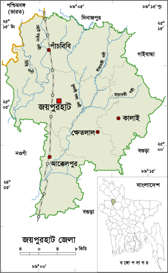
About Joypurhat District, Bangladesh
Joypurhat is small district located in the northern part of Bangladesh. The previous name of the region was “Baghabari Hat” and next it was written “Gopandraganj Hat” in historical documents. During the British East India period, Joypurhat Railway station and post office was established and named Joypurhat to make differ with the name of Joypur located in current India. Then the region got familiarity with the name of Joypurhat with the passing of age. A police station named Joypurhat was established in 1907. Joypurhat was the only subdivision of the formerly Bogra district. After the liberation of Bangladesh, Joypurhat started its journey as a district in 1984. Saotal, Orao, Munda, Mohali, Mohanta, Rajhangshi etc tribes also found in the district and total population of such tribes is about forty seven thousand.
Joypurhat District Bordered By-
Joypurhat District is bordered by Dinajpur, Gaibandha district and West Bengal (Indian State) to the north, Bogra and Naogaon district to the south, Bogra and Gaibandha districts to the east, Naogaon districts and West Bengal to the west.
How many Thana and Union in Joypurhat District?
The area of Joypurhat is 1012.41 Sq Km. It is under Rajshahi Division. There are 04 Municipalities in Joypurhat named Akkelpur, Kalai, Joypurhat and Pachbibi. The number of Thana in Joypurhat district is 05 (Five), named- Joypurhat, Khetlal, Akkelpur, Kalai and Pachbiby. There are 32 Unions, 661 Mauzas and 887 Villages in Joypurhat district.
Why is Joypurhat District Famous For?
Joypurhat district famous for huge amount of agricultural products in Bangladesh. It's specially produced plenty of sugarcane, country's largest suger mill "Joypurhat Suger Mills' located in Joypurhat.
Famous Persons from Joypurhat District
Famous persons born in Joypurhat district are- Bina Pani Sarker, Comored Abdul Kader Chowdhury, Mihir Mukharjee, Ataur Rahaman (Poet), Fatema Tuz Zohara (Singer), Dr Farid Uddin, Dr Abdul Kader Chowdhury, Shahid Mujibur Rahaman, Principal Mohshin Ali Dewan, Abbas Ali Khan, Abdul Alim etc.
Tourist Attractions in Joypurhat District
Tourist attractions in Joypurhat district are- Khasmohol Bhaban, Ber Amla Bershibaloy, Pitarer Banglo, Joypurhat Sugar mills, Cement Factory, Pachbibir Mazar, Nandail Lake, Ashranga Lake, Bastob Puri, Graveyard of Mukshid Gazi, Pagla Dewan Mass Graveyard, Gopinathpur Temple, Shisu Uddyan, Nandail Lake, Ashranga Lake, Joypal Rajar Rajbari, Baro Shibmondir, Shrine of Pathorghata, Abul Quashem Field in Sadar, Central Shahid Minar, Joypurhat Cadette College, English Market etc.
Joypurhat District Population Data
The total population of Joypurhat district is 956,431 (Male- 472,657 and Female- 483,685), sex ratio 100:100, Population Density 944.70/Sq Km and annual growth rate is 0.41%. The Literacy Rate of Joypurhat district is 86.40%, School attendance rate is 94.60% for 5 to 24 years age group. There ere no university, 42 collage (including 3 govt collage), a women cadet collage, 165 secondary high school (including gov. 4), 350 primary school (including gov- 263), a technical school and collage, 13 technical educational institutions, 111 Madrashas, 01 PTI in Joypurhat.
Rivers in Joypurhat District
Rivers flow through Joypurhat district are- Choto Jamuna, Tulshi Ganga, Haramoti, Chiri, Sree Nadi etc.
Agro Products in Joypurhat District
Joypurhat district is called store house of agro pruducts in Northern region. Huge amount of Paddy, Sugarcane, Jute, Turmeric, Banana, Potato, Mango, Jack fruit, Pulses, Yam, Betel Leaf, Tobacco, Oil seeds etc grow in Joypurhat.
Other Important Data: The postal code of Joypurhat district is 5900 and NWD Code is 0571. Total Parliament seat in Joypurhat is 02. During the liberation war, Joypurhat was under Sector Number 07. Urbanization rate of the district is 15.75%. The remarkable Mineral resources of the district are Coal, Limestone etc and average annual average rainfall is 1610 mm.


literacy movement add please.
ReplyDeleteabout people would make better
ReplyDeletemany mistake
ReplyDelete