Wednesday, February 6

Bhola District Information


bhola map
Map of Bhola District

Bhola District, Bangladesh


Bhola is the largest and only one island district of Bangladesh located in the lower basin of Ganga River in the south- western part of Bangladesh. The island was formed in the estuary with the sediment carried by the three major rivers come down from Himalayan named Padma, Meghna and Brahmaputra. The region is average 12 feet above from the sea level. Approximately 1325 AD, the region was started to formed. According to Bakerganj Gazetier written by J C Jack, cultivation was started in the region in 1300 AD. In 1517 AD the island was occupied by a Portuguese pirate named John D. Silabera. The ancient name of the region was “south Shahbajpur”. There are not enough authentic documents about the naming of Bhola. Some historians think that Bhola was named after Bhola Gazi Patni, a boatman who ferried people in the formarly Betua River. During the East India Company period, Bhola sub-division was established in 1854 under Barisal district. It was upgraded to a district on 1 February 1984. Many people of the district, especially of Charfasson and Tazumuddin islands, lost their lives in a devastating cyclone and tidal bore in 1970.

Bordered By: Bhola District is bordered by Barisal and Lakshmipur district to the north, the Bay of Bengal to the south, Lakshmipur and Noakhali districts, the Meghna estuary and Shahbajpur Channel to the east, Patuakhali district and the Tetulia River to the west.

Administration: The area of Bhola is 3403.48 Sq Km. It is under Barisal Division. There are 05 Municipalities in Bhola named Bhola, Charfashion, Borhanuddin, Daulatkhan and Lalmohon. The number of Upazilla (sub district) in Bhola district is 07, named- Bhola Sadar, Charfashion, Monopura, Lalmohon, Daulatkhan, Tazumaddin and Borhanuddin containing 68 Unions, 314 Mauzas and 438 Villages.

Population: The total population of Bhola district is 17,76,795 (Male- 884,069 and Female- 892,726), sex ratio 99:100, population density 522/Sq Km and annual growth rate is 0.42%.

Literacy: The Literacy Rate of Bhola district is 43.30% (Male- 43.60% and Female- 42.90%). School attendance rate is 49.50% for 5 to 24 years age group.

Other Important Data: The postal code of Bhola district is 8300 and NWD Code is 0491. Total Parliament seat in Bhola is 04. During the liberation war, Bhola was under Sector Number 09. Urbanization rate of the district is 13.69%.

Rivers: Meghna, Tetulia, Ilsha, Boalia, Shahbajpur channel etc.

Agro Products: Paddy, Jute, Potato, Onion, Garlic, Chilly, Peanuts, Mastered, Banana, Coconut, Betel Leaf, Betel Nut, Vegetables etc.


Remarkable Personalities from Bhola District

Birshresta Mostafa Kamal, Tofayal Ahmed (Politician), Mozammel Hoque (Poet), Dr Abul Hasan Shamsuddin (Educationist), Firoza Begum (Educationist) Naziur Rahaman Monjur (Politician), Dr Azhar Uddin Ahmad (Politician), Major (Rtd) Hafiz Uddin Bir Bikrom (Politician), Comorad Nalini Das (Politician), Mosharof Hossain Shajahan (Politician), Nasir Ahmed (Poet), Principal Afsar Uddin Babul, Principal Faruquar Rahaman, A K M Makbul Ahmed (Poet), M. Mokammel Haque (Bureaucrate), etc.

bhola, bangladesh

Famous Tourist attractions in Bhola District

Monpura, Bhola Shishu Park, Birsresta Mostafa Kamal Museum, Kheaghat Bridge, Bhorhanuddin helipad, Shabazpur Gas Field, Monopura Island, Graveyard of Tofayel Shah, Kobi Mozammel Hoque Gateway etc.


Bogra District Information


bogra map
Map of Bogra District

Bogra District, Bangladesh


Bogra is an ancient district and the gateway to entrance in the northern part of Bangladesh. In the primitive history of mythology, Bogra has occupied an important role. The previous name of the region was “Pundabardhan”. The ancient capital of Pundra dynasty named Pundrabardhan is the current Bogra. During the 4Th to 12Th century the administrative centre point of the ancient dynasties of Maurja, Gupta, Paul, Sen etc were in the region. Bogra came under the Muslim rule when Ikhtiar Uddin Muhammad Bakhtiyar Khilji conquered Nadia in 1204. During 1279- 1282 AD, Sultan Nasiruddin Bagra Khan, the second son of Sultan Ghiyasuddin Balban who was the emperor of Delhi became the ruler of the region. Bogra was named after him. The anti British movement, Fakir-Sannyasi movement, the Indigo Rebellion etc are the remarkable chapters of the region. During the British East India Company period, Bogra district was established containing 9 police stations in 1821. After the liberation of Bangladesh, Bogra district was divided into two districts named Bogra and Joypurhat in 1983.

Bordered By: Bogra District is bordered by Gaibandha and Joypurhat districts to the north, Sirajganj and Natore districts to the south, Jamalpur district and the Jamuna River to the east, Naogaon and Natore district to the west.

Administration: The area of Bogra is 2898.68 Sq Km. It is under Rajshahi Division. There are 11 Municipalities in Bogra named Dhunat, Kahaloo, Santahar, Sherpur, Dhubchancia, Nandigram, Bogra, Shibganj, Gabtali, Sariakandi and Sonatala. The number of Upazilla (sub district) in Bogra district is 12, named- Bogra Sadar, Dhupchia, Adamdighi, Shibgonj, Dhunat, Shariakandi, Sonatola, Nondigram, Gabtali, Kahalu, Sherpur and Mazhira containing 110 Unions, 1613 Mauzas and 2618 Villages. 

Population: The total population of Bogra district is 34,00,874 (Male- 17,08,806 and Female- 16,92,068). Sex ratio is 101:100, population density 1173/Sq Km and annual growth rate is 1.20%.

Literacy: The Literacy Rate of Bogra district is 49.40% (Male- 52.90% and Female- 45.90%). School attendance rate is 53.70% for 5 to 24 years age group.

Other Important Data: The postal code of Bogra district is 6600 and NWD Code is 051. Total Parliament seat in Bogra is 07. During the liberation war, Bogra was under Sector Number 07. Urbanization rate of the district is 19.71%.

Rivers: Jamuna, Kartoa, Nagor, Bangali, Halhalia, Dakuria, Belai, Gazaria, Chandraboti, Manash, Iramoti, Velka etc.

Agro Products: Sugarcane, Tobacco, Paddy, Jute, Vegetables etc.

Remarkable Personalities from Bogra District

Major Ziaur Ziaur Rahaman( Politician), Noresh Chandra Sen Gupta, Bulbul Chowdhury, Akhtaruzzaman Ilias (Writer), Sadot Ali Akhondo (Literate Personality), Azizul Hoque (Poet), Enamul Hoque (Writer), Lutfar Rahaman Sarker, Sayad Anower Hossain, Chowdhury Mohammad Ali (Politician), Aminul Karim Dulal (Fine Artist), Anjuma Ara Begum (Singer), Khandaker Faruque Ahmed, Gaziul Hoque (Language Fighter), M. R. Akhter Mukul etc.

bogra, bangladesh

Famous Tourist Attractions in Bogra District

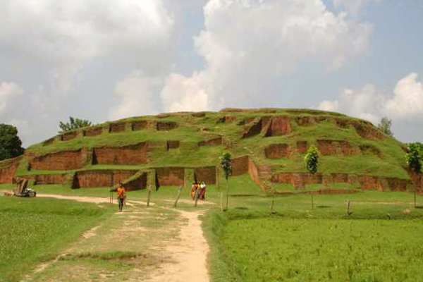
Nawabbari, Kherua Mosque, Mohastangor, Shila Debir Hat, Behula – Luxindor er Bashor Ghor, Vasu Bihar, Bhabani Temple, Graveyard of Shah Sultan Balkhi (R), Bhabanipur Shib Mondir Kherua Mosque in Sherpur, Mohammad Ali Palace, Groan Barrage in Sariakandi, Wonderland etc.


Barguna District Information


barguna map

Barguna District, Bangladesh


The region is located in the south- western part of Bangladesh. Barguna district is average 11 feet above from sea level. There are not enough authentic documents about the naming of Barguna district. Some historians think that once timber traders of northern part came here to buy timbers and they waited for favoring flow (Baro- Gone) of the river of Khakdon to overcome and consequently the region was named Baro-Gona. By the passing of age, Baro- Gona muted to Barguna.  Beside someone thinks that to dragging the boats against the mainstream of tide it was used “Gun.” So the region was named Barguna. Barguna police station was established in the last decade of the eighteenth century. It was upgraded into a sub-division in 1969 and finally the subdivision was turned into a district in 28 February 1984 after the liberation of Bangladesh. The Geo position of the district is between 21˚50’05’’ to 23˚04’10’’ North latitudes and between 89˚59’50’’ to 91˚04’08’’ east longitude.

Bordered By: Barguna District is bordered by Jhalokati, Barisal, Pirojpur and a part of Patuakhali district to the north, Patuakhali district and the Bay of Bengal to the south, Patuakhali district to the east, Pirojpur and Bagerhat districts to the west.

Administration: The area of Barguna is 1831.31 Sq Km. It is under Barisal Division. There are 04 Municipalities in Barguna named Barguna, Patharghata, Betagi and Amtoli. The number of Upazilla (sub district) in Barguna district is 05, named- Barguna, Patharghata, Bamna, Betagi and Amtoli containing 42 Unions, 259 Mauzas and 562 Villages. 

Population: The total population of Barguna district is 892,781 (Male- 437,413 and Female- 455,368), sex ratio 96:100, population density 1439/Sq Km and annual growth rate is 0.50%.

Literacy: The Literacy Rate of Barguna district is 57.60% (Male- 59.20% and Female- 56.10%). School attendance rate is 59.10% for 5 to 24 years age group.

Other Important Data: The postal code of Barguna district is 8700 and NWD Code is 0448. Total Parliament seat in Barguna is 02. During the liberation war, Barguna was under Sector Number 09. Urbanization rate of the district is 11.55%.

Rivers: Haringhata, Biskhali, Dhaleswar, Adhar-Manik, Cheghai, Burishar, Khakdon, Rajgonj etc.

Agro Products: Rice, winter crops, peas, pepper, potatoes, pumpkin, watermelon etc.

Remarkable Personalities from Barguna District

Prof. Sayad Fazlul Hoque, Shelina Hossain (Novelist), Motin Boiragi, Abdul Aziz Master, Dr Entaz Uddin, Delower Hossain Montu, Motiur Rahaman Talukder, Gazi Ali Ahmed etc.

barguna, bangladesh

Famous Tourist Places in Barguna District

Fatrar Char, Ashar Char, Haringhata Forest, Laldiar Char and Sea Beach, Mazhir Char, Sonbunia, Taltoli Rakhain Palli and Temple, Sonakata Forest, Donbunia, Mazhirchar, Khoyra Mosque, Samudra-Bilash, Bibichini Shahi Mosque etc.

Brahmanbaria District Information


brahmanbaria map

Brahmanbaria District, Bangladesh


Brahmanbaria district is located in the eastern part of Bangladesh. Once the region was a part of Samatat state. Later it was included in Tripura district in 1790. The first and temporary capital of Isa Khan was at Sarail, 10 km north of Brahmanbaria Town. Swadeshi movement (1905), Peasant movement (1930) No-rent movement, War of Liberation Movement (1971) etc are the remarkable chapters of the region. Brhamanbaria was promoted as a municipality in 1869. After the liberation of Bangladesh Current Brahmanbaria was declared as a district in 15 February 1984. Before, the region was included in Comilla district. The Geo position of the district is between 23˚29’ to 24˚16’ North latitudes and between 90˚39’ to 91˚21’ east longitude.

Bordered By: Brahmanbaria District is bordered by Kishoreganj and Habiganj district to the north, Comilla district to the south, Habiganj district and Tripura (Indian State) to the east, The Meghna River and a part of Kishoreganj, Narayanganj and Narsingdi districts to the west.

Administration: The area of Brahmanbaria is 1881.20 Sq Km. It is under Chittagong Division. There are 04 Municipalities in Brahmanbaria named Brahamanbaria, Ashugonj, Nabinogor and Kasba. The number of Upazilla (sub district) in Brahmanbaria district is 09, named- Brahamanbaria, Akhaura, Kosba, Bangarampur, Sarail, Nabinagor, Nasirnogor, Ashugonj and Bijoy Nagor containing 100 Unions, 900 Mauzas and 1323 Villages. 

Population: The total population of Brahmanbaria district is 28,40,498 (Male- 13,66,711 and Female- 14,73,787), sex ratio is 93:100, population density 1510/Sq Km and annual growth rate is 1.68%.

Literacy: The Literacy Rate of Brahmanbaria district is 45.30% (Male- 45.7% and Female- 44.90%). School attendance rate is 50.80% for 5 to 24 years age group.

Other Important Data: The postal code of Brahmanbaria district is 3500 and NWD Code is 0851. Total Parliament seat in Brahmanbaria is 06. During the liberation war, Brahmanbaria was under Sector Number 02 & 03. Average rainfall of the district is 78.06 cm urbanization rate of the district is 15.79%. Average rainfall of the region is 187 cm.

Rivers: Meghna, Titas, Shalda, Hawra, Pagla, Putia, Sonai, Hawra, Ropa, Buri, Bizna, Balua, Bolak, Dholbanga etc.

Agro Products: Paddy, Jute, Mastered, Onion, Garlic, Pulses, Pine-Apple, Vegetables etc.

Remarkable Personalities from Brahmanbaria District

Addyata Mollobormon (Novelist), Ostad Ayet Ali Kha (Musical Talent), Ostad Alauddin Kha (Musical Talent), Nawab Syed Shamsul Huda, Samaul Hoque (Poet), Ostad Khadem Hossain Kha (Music Personality), Haralal Roy (Writer), Ma Anyandamoye, Sayed Samsul Huda (Educationist), Oli Ahad (Language Fighter), Al Mahmud (Poet), Ali Imam (Literate Personality), Sayad Abdul Hadi (Singer), Safic Rehman (Editor), Subol Das (Composer), Alamgir (Film Actor), Abdul Kadir (Poet) etc.

brahmanbaria, bangladesh

Famous Tourist attractions in Brahmanbaria District

Titas Gas Field, Graveyard of Birshresta Mostafa Kamal, Kasba Kollapathar Somadhi, Faruque Park, Graveyard of Kallishid (R), Home of Ostad Alauddin Kha, Hatirpul, Home of Biplobi Ullash Datta, Gonga Sagor, Meghna Bridge, Ashugonj Power Station, Jadughor Sahi Mosque, Haripur Landlord Palace etc.


Chandpur District Information


chandpur district map

Chandpur District, Bangladesh


Chandpur district is located in the east central part of Bangladesh. According to the atlas of Major James Renal (1779), we found a minor region named Chandpur. Then government offices of the region were southern part of current Chandpur named Narasinghapur which is currently absorbed in river. The meeting place of mighty Padma and Meghna was then 60 miles southwest from the current location. During the Baro Bhuyan period, the region was under the rule of Chand Narayan Roy. Historian J F Sengupta thinks, Chandpur was named after him. Beside some historians think that Chandpur was named after Chand Fakir of Purindor Moholla (Current Koralia). In 1878, there were four sub divisions named- Sadar North, Sadar South, Brahmanbaria and Chandpur under Tripura district. After the liberation of Bangladesh, Chandpur subdivision was turned into a district in 1984. The area of Chandpur is 1645.32 Sq Km. The Geo position of the district is between 23˚29’ to 24˚04’ North latitudes and between 90˚06’ to 91˚09’ east longitude.

Bordered By: Chandpur District is bordered by Comilla and a part of Munshiganj district to the north, Noakhali, Lakshmipur and Barisal districts to the south, Comilla district to the east, Shariatpur, Munshiganj districts and mighty Meghna River to the west.

Administration: It is under Chittagong Division. There are 07 Municipalities in Chandpur named Chandpur, Hazigonj, Faridgonj, Kachua, Motlob, Chengar-char and Shaharasti. The number of Upazilla (sub district) in Chandpur district is 08, named- Chandpur, Motlob North, Motlob South, Haymchar, Hazigonj, Kachua, Shaharasti and Faridgonj containing 88 Unions, 927 Mauzas and 1230 Villages.

Population: The total population of Chandpur district is 24,16,018 (Male- 11,45,831 and Female- 12,70,187). Sex ratio is 90:100, population density 1468/Sq Km and annual growth rate is 0.61%.

Literacy: The Literacy Rate of Chandpur district is 56.80% (Male- 56.10% and Female- 57.30%)., School attendance rate is 56.80% for 5 to 24 years age group.

Other Important Data: The postal code of Chandpur district is 3600 and NWD Code is 0841. Total Parliament seat in Chandpur is 05. During the liberation war, Chandpur was under Sector Number 02. Urbanization rate of the district is 18.03%.

Rivers: Chandpur town is divided by mighty Dakatia River. Besides Meghna, Dhonagoda, Motlab, Udhamdi etc are the mentionable rivers in Chandpur.

Agro Products: Paddy, jute, wheat, sugarcane, potato, mustard, betel nut, soybean, pepper, vegetables etc.

Remarkable Personalities in Chandpur District

Md Nasir Uddin, (Editor), Burhan Uddin Khan Jahangir (Literate Personality), Nawab Fayjun Nesa Chowdhurany, Hardayal Nag, Mohesh Chandra Vattacharja, Mohes Chandra Vattacharja, Dr Mizanur Rahaman Khan, Major Abdul Goni, Dr Akhter Hamid Khan, A K M Jahirul Hoque, Atindra Mohon Roy, Nawab Sir K G M Faruquee, Hem Prova Majumder, Captain Narendra Nath Datta, Dhrindra Nath Datta, Sachin Deb Barman, Basanta Kumar Majumder, Khan Bahadur Abdul Karim, Nawab Mosharof Hossain, Akhil Chandra Datta, Mohiuddin Khan Alamgir (Politician), Muntasir Mamun (Historian), Mizanur Rahaman Chowdhury (Politician), Samsul Arefin (Literate Personality), Nawab Sir Sayad Samsul Huda, Journalist Nasiruddin, Mawlana Abdul Mannan (Politician), Artist Hashem Khan, Moharaj Birchandra Manikka Bahadur, etc.

chandpur, Bangladesh


Famous Tourist Attractions in Chandpur

Chandpur River Port, River Research Institute, Mole head outfall in Barostation, Remnants of the Nasir Court fort, Baraduara, Historical Baro Mosque of Hazigonj, ICDDR,B in Motlob, Monoshamura, Meghna-Dhangoda Barrage, Nilkuthi, Sahsuja Mosque, Shah Rasti Dargah, Begum Mosque, Hajiganj Bara Mosque, Alamgiri Mosque, Mada Khan Mosque, Kali temple, Ilish Chattor, Lohagara ashram, Naorai ashram, Tultuli (Kachua) ashram, Rare species of plants Naglingam in DC Banglow  etc.