Saturday, February 9

All information about Sylhet Division in Bangladesh


Sylhet Division, Bangladesh


Sylhet is one of the administrative divisions of Bangladesh located in the north- eastern part of the country. Sylhet division is bordered by Meghalaya (Indian State) to the north, Tripura (Indian state) to the south, Assam (Indian state) to the east, Chittagong and Dhaka divisions to the west. Formerly Sri-Hatta is an ancient trading Central point of the region. During the Sultany period, the region was named “Jalalabad”. In the 14Th century Yamany Saint Hazrat Shah Jalal (R) conquered Sylhet and started campaign on Islam. Sylhet district was established on 3 January 1782. Until 1878 AD, the region was under Dhaka division. In the same year in 12 September, Sylhet was included in the newly created Assam Province. Up to 1947 (excepting 1905-1911, the Bangla Vanga Period) it was remain a part of Assam. At the time partion in 1947, it was attached to the East Pakistan and was included in the Chittagong Division as a result of Referendum held on 03 July 1947. There were total 546,815 votes cast on 239 polling stations and a majority of 43.8% voted in favour of East Bengal. The referendum was included in India's independence celebration on 18 July 1947. Nanakara Revolution, Indigo Resistance movement, Anti British Movement (1857) etc are the remarkable chapters of the region. The greater Sylhet was divided into four new districts named Sylhet, Sunamganj, Habiganj and Maulvibazar in 1983-1984. On 1 August 1995, Sylhet was declared as the 6th division of Bangladesh consisting of the four districts of the greater Sylhet. Previously the region was included in Chittagong division. The total area of the division is 12,635.24 Sq Km. Total population of the division is 99,10,219 which is 6.19% of the total population of Bangladesh (male- 49,33,390 and female- 49,76,829). Average sex ratio of the division is 99:100 and annual growth rate is 2.21%. It is the highest growth rate among the division of Bangladesh. The average population density in Sylhet division is 784/Sq Km. Among the population 10,98,232 live in urban area, 364,479 live in other urban area and 84,47,508 people live in rural area. The average literacy rate of the division is 45.00% (Male- 47.00% and female- 43.10%). Average school school attendance rate is 48.00% for 5 to 24 years old. The average urbanization rate of the division is 14.76%. The region has an extraordinary tourism potentials. There is a vast area of green carpet of tea plants on small hillocks. Jaflong falls, Madhabkunda falls, the shrine of Hazrat Shah Jalal (R) etc are the other most attractive tourist places in the region. The 04 districts of Sylhet division are as follow-


                                     1. Sylhet
                                     2. Moulvibazar
                                     3. Sunamganj
                                     4. Habiganj

Largest District          : Sunamgonj (3,747.18 Sq Km)
Smallest District        : Habiganj (2,636.59 Sq Km)
City Corporation         : 01
Municipality               : 19
Upazilla                     : 38
Union                        : 333
Village                      : 10250                    
Parliament Seat         : 19


All information about Rangpur Division, Bangladesh


Rangpur Division, Bangladesh


Rangpur is the newest and seventh administrative division in Bangladesh. The region is famous for its cheap labors. It is located in the northern part of Bangladesh and bordered by West Bengal (Indian state) to the north, Rajshahi division to the south, Assam, Meghalaya (Indian state) and a part of Dhaka division to the east and west Bengal to the west. The ancient name of the region is “Mughalbasa”. Mansingh, the commander of Mughal Emperor Akbar conquered part of the region in 1575 AD. Rangpur came under the Mughal rule completely in 1686 AD. Mughalbasa and Mughalhat of the region (currently in Kurigram district) still bear marks of the Mughal rule in the region. During the Mughal rule Rangpur was under the sarker of Ghoraghat. During the early period of the East India Company rule Fakir- Sannyasi resistance and peasant rebellion were broke out in the region. The district is formed in 1772 AD. The region has a lot of natural resources but comparatively less developed. To accelerate the development of the region on 25 January 2010, Rangpur Division was formed. There is a strong rail and land communicating infrastructure in the region. A number of buses and 21 express trains run everyday to communicate among the districts of the division and also to the other part of the country. There is no international airport but three local airports. Among the local airports Sayadpur Airport is busy one. There are 08 districts in Rangpur division. The total area of the division is 16,185.01 Sq Km. Total population of the division is 1,57,87,758 (male- 78,81,824 and female- 79,05,934) which is about 9.87% of the total population of Bangladesh. Average sex ratio of the division is 100:100 and annual growth rate is 1.30%. The average population density in Rangpur division is 975/Sq Km. Among the population 16,03,222 live in urban area, 505,849 live in other urban area and 1,36,78,687 people live in rural area. The average literacy rate of the division is 47.20% (Male- 50.60% and female- 43.80%). Average school attendance rate is 55.00% for 5 to 24 years old. The average urbanization rate of the division is 13.36%. The 08 districts of Rangpur division are as follow-
            1. Rangpur 
            2. Dinajpur
            3. Gaibandha 
            4. Kurigram 
            5. Lalmonirhat 
            6. Nilphamari
            7. Panchagarh
            8. Thakurgaon


Largest District            : Dinajpur (3444.30 Sq Km)
Smallest District         : Lalmonirhat (1247.37 Sq Km)
City Corporation         : 01
Municipality               : 27
Upazilla                     : 58
Union                        : 539
Mauza                       : 6523
Village                      : 9050
Parliament Seat         : 33


Thursday, February 7

Bagerhat District Information


Atlas of Bagerhat, Bangladesh
Atlas of Bagerhat District


Bagerhat District, Bangladesh


Bagerhat district located in the south western part of Bangladesh. The ancient name of the region was “Khalifatabad.” It is debatable about the naming of Bagerhat. Some historians think that the region is adjacent to Sundarban and the the region once under the raid of tigers (Bagh). So it is called “Bagher Hat.” By the passing of age the word Bagher- Hat turned into Bagerhat. Some researchers think that Bagerhat came from the name of “Baker Hat” that once sat on the northern part of Vhariab River. Some Historians think that the “Khalifa –e- Abad” established by Khan Jahan Ali (R) that Bag (garden) convert to Bagerhat by the passing of age. The name of great saint Khan Jahan Ali (R) is related to the history of Bagerhat. He migrated here in 1429 (debatable) with a number of followers from Delhi and established the Khalifabad Pargana covering areas including Bagerhat, Khulna, Satkhira, Jessore and Barisal. He ruled this pargana during the period from 1429 to 1449. After his death in 1449, Raja Prajapaditya conquered the Pargana. During the British East India Company Period, Bagerhat police station was established in 1842 under Khulna subdivision. The region was upgraded into subdivision under Jessore district in 1863. During the war of liberation in 1971 the Pakistani army entered Bagerhat on 21 April through the land way via Domer-pool. They killed about 200 innocent civilians at Khalishakhali and Babuganj. Many people were killed and wounded in encounters between the Pakistani army and the freedom fighters at Doyapara, Shakharikarihat and at Chakulia of Mollahat. Besides, 35 people were killed in an encounter between the freedom fighters and the Razakars (supporters of enemy army) in Morrelganj. Bagerhat subdivision was turned into a district on 23 February 1984. The Geo position of the district is between 22˚32’ to 22˚56’ North latitudes and between 89˚32’ to 89˚48’ east longitude.

Bordered By: Bagerhat District is bordered by Faridpur district to the north, The Bay of Bengal to the south, Pirojpur, Barguna and a part of Gopalganjdistrict to the east, Khulna district to the west.

Administration: The area of Bagerhat is 3959.11 Sq Km. It is under Khulna Division. There are 03 Municipalities in Bagerhat named Bagerhat, Mongla and Moralgonj. The number of Upazilla (sub district) in Bagerhat district is 09, named- Bagerhat, Mollarhat, Fakirhat, Mongla, Kachua, Rampal, Sharankhola, Moralgonj and Chitalmari containing 76 Unions, 697 Mauzas and 1048 Villages. 

Population: The total population of Bagerhat district is 14,76,090 (Male- 740,138 and Female- 735,952), sex ratio 101:100, population density 373/Sq Km and annual growth rate is (-) 0.47%.

Literacy: The literacy rate of Bagerhat district is 59.00% (Male- 60.00% and Female- 58.00%), school attendance rate is 57.70% for 5 to 24 years age group.

Other Important Data: The postal code of Bagerhat district is 9300 and NWD Code is 0468. Total Parliament seat in Bagerhat is 04. During the liberation war, Bagerhat was under Sector Number 08 & 09. Urbanization rate of the district is 13.23%.


Rivers: Mongla, Modhumoti, Shila, Haringhata, Baleshari, Pathuria, Bangra, Daratana, Panguchi, Pashur, Vangra, Goshairkhali etc.

Agro Products: Paddy, jute, banana, coconut, betel Leaf, betel nut, peas, potato, watermelon, sugarcane, vegetables etc.

Remarkable Personalities from Bagerhat district

Dr Nilima Ibrahim (Writer), Sree Das Gupta (Politician), Rudra Mohammad Shahidullah (Poet), Prof. Abdullah Abu Sayed (Writer and Social Worker), Prof. Abu Baker Shiddique, Sheikh Amjad Ali, Kiron Chandra Roy, A. S. M. Mostafizur Rahaman, Prof. Moazzem Hossain, Prof. Kazi Azhar Ali, Prof. Ruhul Amin, Dr Sheikh Gaus Mia, Bidhu Vushan Basu, Sheikh Kamruzzaman Tuku (Commander of Mujib Bahini) etc.

bagerhat, bangladesh
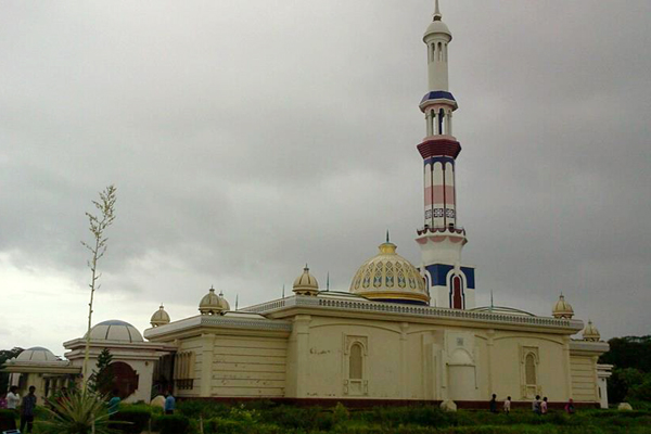
Shat Gambuj Mosque, Bagerhat ( one of the World Heritages)

Famous Tourist Attractions in Bagerhat District

Shat Gambuj Mosque, Chandra Mahal, Graveyard and Lake of Khan Jahan Ali, Ghoradighi, Mongla Sea Port, Sundarban, Robart Morel Monument, Modhumala Temple and Lake, Buffalo Cultivation Centre, Panighata Lake, Sona Mosque, Ajoddha Temple, Shib Temple, Hiron Poient, Tagore Lake, Rampal Lake, Seven and Nine Tomb Mosque, Kodla Math, Durgapur Shiva Math, Mongla Sea Port  etc.

Bandarban District Information


Map of Bandarban District

Bandarban District, Bangladesh


Bandarban district is located in the south eastern part of Bangladesh. There is a myth among the local civilians of the region about the naming of Bandarban. They believe that once a number of Banor (Monkey) lived in the region. They came nearby the falls (Chara) to eat salt and then the region got familiarity with the name of “Maokshi Chara”. Maok means Monkey and Chara means Dam. But according to the Marma’s language the original name of the region is “Rod Kaochi Mrow”.  During the British East India Company period Chittagong hill tracts was declared as a district in 1860. Then the region was under the district of Chittagong Hill Tracts. According to the Chittagong Hill Tracts Regulation 1900, the whole Chittagong Hill Tracts was divided into three Circles named- Chakma Circle, Mong Circle and Bomang Circle. Current Bandarban district was under formerly Bomang Circle. So the ancient name of the region was “Bomang Thong”. Then the region was declared as a forest zone when it is a vast forest area and devoid of human settlement. The Arakanies were permanently settled in the region after the British ascendancy in Arakan. During the Pakistan Period the region was declared as a subdivision in 1951. After the liberation of Bangladesh, formerly Lama Subdivision including seven sub districts started its journey as a district in 18 April 1981.  The Geographical position of the district is between 21˚11’ to 22˚22’ North latitudes and between 92˚40’ to 92˚41’ east longitude. It is one of the most tourists’ attractive areas of Bangladesh. The highest peak of Bangladesh “Bijoy” is located in the region.

Bordered By: Bandarban District is bordered by Rangamati district to the north, Arakan (a state of Mayanmer) and the Naf River to the south, Indian Border and Rangamati district to the east, Chittagong and Cox’s Bazar districts to the west.

Administration: The area of Bandarban is 4479.01 Sq Km. It is under Chittagong Division. There are two Municipalities in Bandarban named Lama and Bandarban. The number of Upazilla (sub district) in Bandarban district is 07, named- Bandarban, Rawoangchari, Naikharchari, Alikadam, Ruma, Thanchi and Lama containing 30 Unions, 96 Mauzas and 1554 Villages.

Population: The total population of Bandarban district is 3,88,335 (Male- 2,03,350 and Female- 1,84,985). Sex ratio is 110:100, population density 87/Sq Km and annual growth rate is 2.64%.

Literacy: The Literacy Rate of Bandarban district is 35.90% (Male- 40.30% and Female- 30.90%). School attendance rate is 44.50% for 5 to 24 years age group.


Other Improtant Data: The postal code of Bandarban district is 4600 and NWD Code is 0361. Total Parliament seat in Bandarban is 01. During the liberation war, Bandarban was under Sector Number 01. Urbanization rate of the district is 25.86%. The maximum temperature of the district is 34.6˚ C. and minimum 13˚ C. Average Rainfall 3031 mm.

Rivers: Matamuhari, Sangu, Rankhiang, Bak Khali etc.
Agro Products: Ginger, turmeric, sesame, cotton, pine apple, almonds, orange, banana, jack-fruit, lemon, tobacco, vegetables etc.

Remarkable Personalities from Bandarban District

Koarsha ong Marma, Mongsha Pru, Dr Mang Usha, Thoai Marma, Dr Prushanu Marma, U K Ching (Bir Bikram) etc.

bandarban, bangladesh


Famous Tourist Attractions in Bandarban District

Bomang Royal Palace, Baktai and Pukura Para Cascade, Bijoy the Highest Peak of Bangladesh, Keokaradong Peak, Chimbuk Hill, Meghla Parjatan Complex, Nilachal, Nilgiri, Shoila Propat, Prantik Lake, Chimbuk, Boga Lake, Rijuk Fall, Keokradong, Tahjingdong, Shangu River, Golden Temple, Mirinja Parjatan, Upabon Parjatan etc.


Barisal District Information


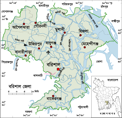
Barisal District Map
Map of Barisal District


Barisal District, Bangladesh


Barisal is located in the south- central part of Bangladesh. The ancient name of the region was “Chandradip.” The capital of the kingdom was Bakla founded by Danuj Madhab or Danuj Mardhan Dev. Formerly Bakerganj district was established in 1797. Later it was renamed as Barisal district. Barisal was declared a division on 1 January, 1993. The Geo position of the district is between 22˚42’ North latitudes and between 90˚22’ east longitude. Barisal is called the “Sassya Vander” (store of corns) of Bangladesh.

Bordered By: Barisal District is bordered by Madaripur, Shariatpur, Chandpur and a part of Lakshmipur district to the north, Patuakhali, Barguna and Jhalokati Districts to the south, Bhola and Lakshmipur districts to the east, Gopalganj, Pirojpur and Jhalokati districts to the west.

Administration: The area of Barisal District is 2784.52 Sq Km. It is also a Divisional Headquarter. There is a city corporation; 05 Municipalities in Barisal named Mehidigonj, Bakergonj, Muladi, Banaripara and Gaurnadi. The number of Upazilla (sub district) in Barisal district is 10, named- Agailjhara, Gaurnadi, Babuganj, Bakerganj, Hizla, Mehendiganj, Barisal Sadar, Banaripara, Muladi and Wazirpur containing 85 Unions, 1001 Mauzas and 1116 Villages outside of metro area.

Population: The total population of Barisal district is 23,24,310 (Male- 11,37,210 and Female- 11,87,100), Sex ratio 96:100, Population Density 1439/Sq Km and annual growth rate is (-) 0.13%.

Literacy: The Literacy Rate of Barisal district is 61.20% (Male- 61.90% and Female- 60.60%); school attendance rate is 59.60% for 5 to 24 years age group.

Other Important Data: The postal code of Barisal district is 8200 and NWD Code is 0431. Total Parliament seat in Barisal is 06. During the liberation war, Barisal was under Sector Number 08 & 09. Urbanization rate of the district is 22.33%. Annual rainfall of the region is 1955 mm.

Rivers: Meghna, Ilisha, Kittonkhola, Arial-Kha, Tetulia, Biskhali, Hisla, Bakerganj, Kaligira, Kalabador, Lohania, Sandha, Ramgonj, Gojalia etc.

Agro Products: Paddy, Jute, Sugarcane, Onion, Guava, Betel Leave, Mango, Jack fruit, Banana, Vegetables, Oilseed etc.


Remarkable Personalities from Barisal District

Birshresta Mohiuddin Jahangir, Ashini Klumar Datta (Politician), Major Abdul Jalil, Sashivhusan Das Gupta (Poet), Abdul Jabbar Khan (Singer), Humayun Kabir (Writer), Abdul Gaffar Chowdhury (Writer and Journalist), Abu Jafor Obaidullah (Writer and Poet), Asad Chowdhury (Poet), Sarder Fazlul Karim (Writer), Sufia Kamal (Poet), Adi Kobi Minnath, Monosha Mongol Poet Bijoy Gupta, Mukunda Das (Poet), Abdur rahaman Biswas (Politician), Shere Bangla A. K. Fazlul Hoque (Politician), Altaf Mahmud (Music Director), Jibananda Das (Poet), Kushum Kumari Das (Poet), Abdul Rob Sherniabat (Politician), Golam Mostafa (Actor), Subarna Mostafa (Actress), Papia Sarwar (singer), Rejowana Chowdhury Bannya (Singer), Amrita Lal Day (Writer), Mithun Chakroborti (Indian Hero), Rashed Khan Menon (Politician) etc.

barisal, bangladesh


Famous Tourist Places in Barisal District

Brojomohan University College, Village of Sher-e-Bangla Chakher, Sher-e-Bangla Medical College, Durgasagor Lake, Oxford Mission Church, Ulania Royal Palace, Kittonkhola River, Subabad Fort, Shankor Temple, Jora Mosque, Sujabad Fort, Sangram Fort, Narikel Fort, Sher-e-Bangla Museum, The Bangabandhu Uddan (former Bell's Park), Shahid Abdur Rab Serniabat Bridge etc.