Wednesday, December 18

Pirojpur District Information


atlas of pirojpur district


Pirojpur District, Bangladesh


Pirojpur district is located in the south- western part of Bangladesh. Most of the land of the region is low laying plane and 10 to 19 feet above from sea level. It is said that Pirojpur was named after Landlord Firoj Shah, the son of Shah Suja. At the first time the region was named “Firojpur” and by the passing of time the word Firojpur slowly muted to Pirojpur. During the East India company period, the pirojpur subdivision was formed in 1866. After the liberation of Bangladesh Pirojpur subdivision was upgraded into district in 01 March 1984. Peasant Rebellion (1757), Indigo Resistance movement etc are the remarkable chapters of the region. The Geo position of the district is between 22˚30’ to 22˚52’ North latitudes and between 89˚52’ to 90˚13’ east longitude.

Pirojpur District Bordered By

 Pirojpur District is bordered by Barisal and Gopalganj districts to the north, Barguna district to the south, Jhalokati and Barguna districts to the east, Bagerhat district and the Sundarban, the largest mangrove forest to the west.

Administration: The area of Pirojpur is 1277.80 Sq Km. It is under Barisal Division. There are 03 Municipalities in Pirojpur named Pirozpur, Nesarabad and Mothbaria. The number of Upazilla (sub district) in Pirojpur district is 07, named- Pirojpur Sadar, Vandaria, Mathbaria, Zianagor, Nazirpur, Sharupkathi and Kaukhali containing 51 Unions, 390 Mauzas and 648 Villages. 

Pirojpur District Population

The total population of Pirojpur district is 11,98,195, Sex ratio 100:105.60, Population Density 938/Sq Km, annual growth rate is 0.53%.

Literacy: The Literacy Rate of Pirojpur district is 85.53%. School attendance rate is 88.09% for 5 to 24 years age group.

Other Important Data: The postal code of Pirojpur district is 8500 and NWD Code is 0461. Total Parliament seat in Pirojpur is 04. During the liberation war, Pirojpur was under Sector Number 08 & 09. Urbanization rate of the district is 16.41% and distance from capital city Dhaka is 184 Km. Average rainfall of the region is 2240 mm.

Rivers: Gabkhan, Baleshwar, Damodar, Kocha, Pona, Kochakhali, Kaligonj, Sandha etc.

Agro Products: Paddy, Jute, Sugarcane, Wheat, Guava, Banana, Coconut, Hog-plum, betel leaf, betel nuts etc.


Remarkable Personalities from Pirojpur District

Poet Begum Sufia Kamal, Ahsan Habib (Poet), Moinur Ahsan Saber, Sayad Azizur Hoque(Poet), Tofazzal Hossain Manik Mia (Journalist), Moazzem Hossain, Biswajit Ghosh, Barister Moinul Hossain, Juwel Ice (Magician), Mawlana Abdur Rahim, Major General (Rtd.) Nurul Islam, Dr Khitish Chandra Mondol, Anower Hossain Monju (Politician), Leader Mahiuddin Ahmed, M. U. Ahmed, Manik Miah etc.

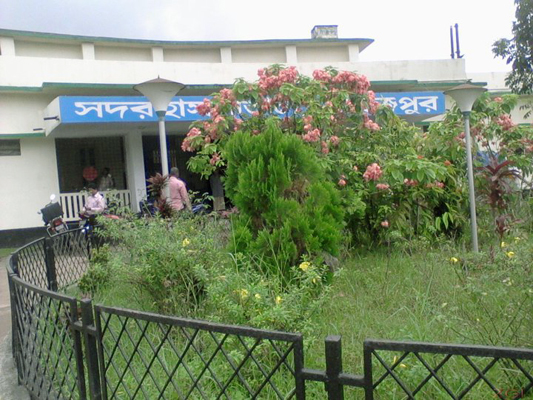
pirojpur sadar hospital


Tourist Attractions in Pirojpur District

Mothbaria Shapjora Kuthibari, Rayerkathi Royal Palace and Temple, Kumarkhali Kali Mandir, Two Domed Mosque (Nesarabad), Remnants of Kaurikhara Zamindarbari, Baleswar DC Park, Majherchar, Floating Vegetable Garden of Nazirpur, Guava Orchard of Nesharabad, Pathorghata Sea Beach etc.


Rajbari District Information


atlas of rajbari district


Rajbari District, Bangladesh

Rajbari district is located in the central region of Bangladesh. There was no doubt; Rajbari was named after a Royal Palace. But it is not clear when the king and after which Rajbari was named after. Some historians think that the region was named after the royal palace of King Surjakumar Sen (1885). Almost all the region of the district was made by sediment of mighty Padma River. Historical Records of the time of permanent settlement (1793) show that the whole area was under the jessore district. The area was included in Faridpur district when it was established in 1811. When Goalanda subdivision was formed in 1871, Pangsha and Rajbari were included with it and headquarter was established at Rajbari. In 1883 Rajbari was upgraded to a sub district and upgraded into a municipality in 1923. After the liberation of Bangladesh, 01 March 1984 Rajbari was again upgraded into a district. The Geo position of the district is between 23˚35’ to 23˚55’ North Latitudes and between 89˚09’ to 89˚55’ east Longitude.

Rajbari District Bordered By

 Rajbari District is bordered by Pabna district to the north, Magura and Faridpur districts to the south, Manikganj district to the east, Kushtia and Jhenaidah districts to the west.

Administration: The area of Rajbari district is 1092.28 Sq Km. It is under Dhaka Division. There are 03 Municipalities in Rajbari named Rajbari, Goalonda and Pangsha. The number of Upazilla (sub district) in Rajbari district is 05, named- Rajbari, Goalonda, Pangsha, Baliakandi and Kalokhali containing 42 Unions, 720 Mauzas and 967 Villages. 

Rajbari District Population

 The total population of Rajbari district is 11,89,818. Sex ratio is 98:100, Population Density 1089/Sq Km and annual growth rate is 1.10%.

Literacy: The Literacy Rate of Rajbari district is 69.49%, School attendance rate is 71.10% for 5 to 24 years age group.

Other Important Data: The postal code of Rajbari district is 7700 and NWD Code is 0641. Total Parliament seat in Rajbari is 02. During the liberation war, Rajbari was under Sector Number 08. Urbanization rate of the district is 12.96%, and average rainfall is 2105 mm. Average Moisture is 75%.

Rivers: Padma, Chandna, Chitra, Horai, Gorai, Madhumoti, Kumar etc. 

Agro Products: Paddy, Jute, Wheat, Onion, garlic, Yam, Turmeric, Ground- Nut, Pulses, Oil seeds, Mango, Jack fruit, Black- Berry, Coconut, Palm, Litchi etc.


Remarkable Personalities from Rajbari District

Mir Mosharrof Hissain (Writer), Dr Kazi Motahar Hossain (Educationist), Mohammad Yaqub Ali Chowdhury (Education Reformist), Maulvi Tamizuddin Khan (Speaker in formerly East Pakistan Parliament), Roknuzzaman Khan Dada Vi (Cartoonist),  Prof. Jahanara Begum, Roknuzzaman Khan, Dr Fakir Abdur Rashid, Fakir Abdul Jabbar, Kazi Abdu Odud (Writer), Monsurul Karim (Fine Artist), Nafees Bin Jafor (Oscar Winner) etc.


Tourist Attractions in Rajbari District

Luxmi Kol Royal Palace, Baliakandi Royal Palace, Children Park, Graveyard of writer Mir Mosharrof Hossain, Memorial Center, Acrobatic Center, Rajbari Swiming Pole, Dauladia River Port, Rajbari Circuit House, Rajbari Uddyan Base, Jora Bangla Temple, Sawdagor Mound, Shrine of Shah Palowan, Tomb of Saint Kamal Shah, Dauladia Ferry Ghat  etc.


Rajshahi District Information


rajshahi city map, Bangladesh


Rajshahi District, Bangladesh


The previous name of the region was “Barendravhumi”. Rajshahi district was a part of Pundrubardhan of the ancient Banga State. The capital of Vijoy Sen was located 9 miles away to the west of Rajshahi town. Indigo resistance movement spread over Rajshahi during 1859-60. During the mass upsurge in 1969 Dr. Shamsuzzoha, a prominent professor of Rajshahi University was killed when the great soul stood forward to protect his students. Rajshahi district was established in 1772. Maldaha, Bogra, Pabna, Natore and Nawabganj districts were established dividing this district. The Geo position of the district is between 24˚07’ to 24˚43’ North latitudes and between 88˚17’ to 88˚58’ east longitude.

Rajshahi District Bordered By

 Rajshahi District is bordered by Naogaon district to the north, Kushtia district, West Bengal (Indian State), and the Ganga River to the south, Natore district to the east and Chapai Nawabganj district to the west.

Administration: The area of Rajshahi is 2425.37 Sq Km. It is a divisional Headquarter also. There are a city corporation 14 Municipalities in Rajshahi named Kesharhat, Bagha, Arani, Tanore, Katakhali, Mundumala, Charghat, Noahata, Godagari, Puthia, Durgapur, Bhabaniganj, Kakanhat and Tahirpur. The number of Upazilla (sub- district) in Rajshahi district is 13, named- Patia, Paba, Rajpara, Bagmara, Tanore, Boalia, Mohonpur, Charghat, Bagha, Godagari, Durgapur, Motihar and Sah-Makhdum containing 71 Unions, 1393 Mauzas and 1727 Villages outside of metro area.

Rajshahi District Population

The total population of Rajshahi district is 29,15,009. Sex ratio is 102:100, Population Density 1202/Sq Km and annual growth rate is 1.00%.

Literacy: The Literacy Rate of Rajshahi district is 53.00% (Male- 55.80% and Female- 50.10%). School attendance rate is 58.90% for 5 to 24 years age group.

Other Important Data: The postal code of Rajshahi district is 6000 and NWD Code is 0821. Total Parliament seat in Rajshahi is 06. During the liberation war, Rajshahi was under Sector Number 07. Urbanization rate of the district is 32.93%.

Rivers: Padma, Jamuna, Atrai, Mohanonda, Gur, Musakhan, Nandakuja Gumani, Norod, Boral etc. 

Agro Products: Mango, Paddy, Jute, Sugarcane, Litchi, Pulse, Wheat, Tobacco, Peanuts, Betel, Betel- Nuts etc.

Remarkable Personalities from Rajshahi District

Abdul Ahad, Abul Hasanat, Mohammad Kamruzzaman, Charu Mazumder, Dhirendra Nath Sarker, Monjur Morshed (Literate Personality), Shelina Hossain (Literate Personality), Tarikul Islam, Mirza Yousouf Ali, Ayen Uddin, Hazrat Shah Mokhdum (R), A. H. M. Kamruzzaman (Politician), Martyr Prof. Samsuddoha, Mir Azizur Rahaman (Poet), Endru Kishor (Singer) etc.

famous mango of rajshahi


Famous Tourist Attractions in Rajshahi

Shah Mokhdum Mazar, Bagha Mosque, Rajshahi Sugar Mills, Borendra Museum, Silk Industry, Rajshahi University, Rajshahi Medical College, Barokuthi, Sarda Police Training Center, Antique of Putia, Godagari Royal Palace, Graveyard of Mirza Alikuli Beg, Porsha Royal Palace, Bhubon Mohon Park, Rajshahi Cadet College, Puthia Temple Complex, Kismat Madia Mosque, Tomb of Hazrat Shah Sultan, Bara Kuthi, Talando Shiva Mandir etc.


Rangamati District information


atlas of rangamati district


Rangamati District, Bangladesh


Rangamati is a hilly district of Bangladesh located in the south eastern part of the country. Before the Muslim conquest, Rangamati region was a contesting ground between the kings of the Arakan and the Tripura. As a result the Royal dynesty’s founder King Juja Rupa (Bira King) defeats the king of Chittagong and transferred his capital in Rangamati in 590 AD. Arakan King Tsula Tsandra (951-957) conquered Chittagong including Greater Chittagong Hill Tracts in 953 AD. In 1240 Tripura King re-Conquered the region. In 1266 this region came under the Mughals. It was leased to the English East India Company in 1760-1761. In 24 June 1787, formerly ruler Arakan King wrote to the chief to Chittagong that some tribes (Mogh, Chakma, Murang and Lice) took shelter in Chittagong Hill tracts and persecuted the people of both countries. Arakanis King wished to drive out the robbers so that the friendship between the two countries remain clean and the roads to transport the businessmen and tourists remain safe. In 1829, the commissioner of British East India Company recognized that the inhabitants of mountaineer are not British subjects but taxpayer only. According to the Act XXII In 1860, the region was separated from Chittagong that effected from 20 June in the same year and started its journey as a district. In 1868, the district headquarter was shifted from Chandraghona to Rangamati. After the liberation of Bangladesh, in 25 February 1985 due to administrative reform, Rangamati, Khagrachari and Bandarban district newly named and reformed. The Geo position of the district is between 22˚27’ to 23˚44’ north latitudes and between 91˚56’ to 92˚33’ east longitude. It is the largest district of Bangladesh in area and the area of the district is 6,116.11 Sq Km. Before the formation of three districts the greater Chittagong Hill Tracts was called “Carpas Mahal (1715-1860).

Rangamati District Bordered By

Rangamati District is bordered by Tripura and Mizoram (Indian State) to the north, Bandarban district to the south, Mizoram (Indian State) and Chin State (Mayanmar) to the east, Khagrachari and Chittagong district to the west.

Administration: Rangamati district is under Chittagong Division. There are two Municipalities in Rajgamati named Rajgamati and Baghaichari. The number of Upazilla (sub district) in Rangamati district is 10, named- Bagaichari, Langadu, Naniarchar, Rajasthali, Barkul, Rangamati Sadar, Kawkhali, Belaichari, Kaptai and Juraichhari containing 49 Unions, 162 Mauzas and 1555 Villages. 

Rangamati District Population

 The total population of Rangamati district is 666,627. Sex ratio is 111:100, Tribal and Non Tribe ratio 52:48, Population Density 109/Sq Km and annual growth rate is 0.64%.

Literacy: The Literacy Rate of Rangamati district is 85.62%, school attendance rate is 79.29% for 5 to 24 years age group.

Other Important Data: The postal code of Rangamati district is 4500 and NWD Code is 0351. Total Parliament seat in Rangamati is 01. During the liberation war, Rangamati was under Sector Number 01. The number of tribal live in the district is 11 and urbanization rate of the district is 26.78%. The highest peak of the hilly district is Thang- Nang (2409 Feet). The main traditional festival of the tribe inhabitants is Bijhu Festival. 

Rivers: Karnafuli, Shankha, Rankhiang, Kashaling, Mayani etc. 

Agro Products: Paddy, Jute, Potato, Cotton, Pine-Apple, Banana, Jack-Fruit, Orange, Litchi, Oil seeds etc.

Remarkable Personalities from Rangamati District

Alamgir Kabir (Film Director), Kanak Chapa Chakma, King Debashis Roy, Raja Tribid Roy (Former Chakma King), Moharaja Tridib Roy, Moharany Moitry Roy, Barister Debashis Roy, Ashok Kumar Dewan, Krishna Kishor Chakma, Moni Shopon Dewan etc.

hanging bridge in rangmati


Tourist Attractions in Rangamati District

Sabuj Pahar, Home of Chakma King, Hanging Bridge and Parjapan Motel in Tabalchari Deer Park, Kaptai Lake, Hydro Electric Power Plant, Hard Board Mill, Karnafuli Paper Mill, Baghai Chari Kashalong River, Buddhist Bihar, Shuvolang Falls, Tribe Museum, Kaptai National Park, Peda Ting Ting, Tuk Tuk Eco Village etc.