Thursday, December 19

Natore District Information


atlas of natore


Natore District, Bangladesh


Natore district is located in the northern part of Bangladesh. Once Natore was a low lying land (bil) that name was “Chaivhanga.” A myth spreads about the naming of Natore that one day Raja Ramjibon Roy was traveling by boat through the famous Chalan Bil located in the region and saw that a frog caught a snake. By seeing this he ordered the boatmen- “Nao Thamao” (stop the boat) and decided to establish his capital in the region. From this word ‘Nao Thamao’ placed “NATORE” by the passing of age. As usual Raja Ramjibon Roy established his capital here in 1706 by filling the low lying lands. Natore was the central office of greater Rajshahi district till 1821. Natore subdivision was established in 1845 under Rajshahi district and upgraded into municipality in 1869. Indigo resistance movements were broke out in this region in 1859- 1860. Natore district is adjacent to the Barandra region that was famous for ancient traditional archaeological treasures. At the eve of the end of Muhal era, Natore became the central point of the power of Bengal. The region was famous for the historical dynasty of Rani Bhabani who was famous for his activities to mankind. During the War of Liberation in 1971 a direct battle was fought between the Pakistani army and the freedom fighters on 29 March in which about 40 members of the Pakistani army including Major Aslam and Capt Ishaq were killed. Natore was turned into a district again in 1984. The Geo position of the district is 24˚26’ North latitudes and 89˚9’ east longitude.

Natore District Bordered By

Natore District is bordered by Naogaon and Bogra districts to the north, Kushtia and Pabna districts to the south, Sirajganj and a part of Pabna district to the east, Rajshahi district to the west.

Administration: The area of Munshiganj is 1900.19 Sq Km. It is under Rajshahi Division. There are 08 Municipalities in Natore named Gurudaspur, Natore, Shingra, Gopalpur, Boraigram, Bagatipara, Naldanga and Bonpara. The number of Upazilla (sub district) in Natore district is 06, named- Natore Sadar, Lalpur, Bagaripara, Baraipara, Shingra and Gurudaspur containing 52 Unions, 1068 Mauzas and 1351 Villages.

Natore District Population-

The total population of Natore district is 18,59,922 (Male- 8,54,183 and Female- 852,490). Sex ratio is 97.88:100, Population Density 978.80/Sq Km and annual growth rate is 0.77%.

Literacy: The Literacy Rate of Natore district is 71.51% (Male- 51.90% and Female- 47.30%). School attendance rate is 77% for 5 to 24 years age group.

Other Important Data: The postal code of Natore district is 6400 and NWD Code is 0771. Total Parliament seat in Natore is 04. During the liberation war, Natore was under Sector Number 07. Urbanization rate of the district is 13.36%.

Rivers: Atrai, Boral, Nagor, Tulshi, Nondakuiwa, Gaurnadi etc.

Agro Products: Paddy, Jute, Sugarcane, Pulse, Peanuts, Water-Melon, Vegetables etc.


Natore District Famous For-

Natore is famous for Kachagolla- a dessert made of dairy ingredients and sugar. Natore is also famous for making of gold ornaments. There are about 500 Jewelery shops in Natore district. 


Remarkable Personalities from Natore District

Moharaj Jagadindra Nath Roy, Maharanee Bhabanee (an Independent Jamindar of Natore during British India), Banalata Sen (Fictional character), Jadunath Sarker, Abdus Satter, Rani Bhabani, Dr Motiur Rahaman, Principal Abdul Hamid, L. Bari, Prof Musleh Uddin  etc.

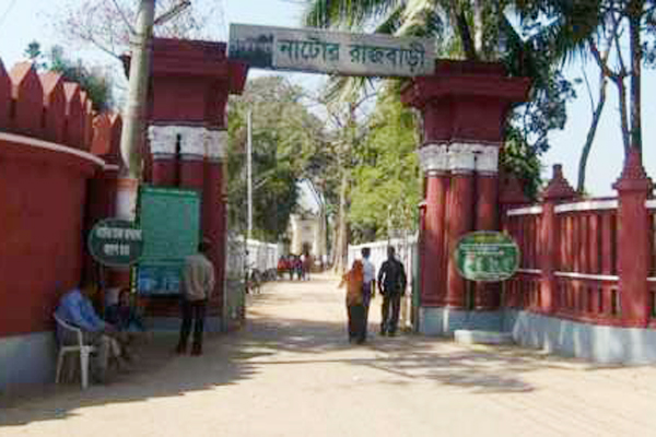
natore royal palace


Tourist Attractions in Natore District

Rani Bhabanir Royal Palace and Museum, Gopal temple, Digha-Patia Royal Palace (Uttara Ganobhabon), North Bengal Sugar Mills, Sahid Sagor, Chalan-Bil, Graveyard of Hazrat Kubir Shah, Pagla Raja's Palace (jubo park), Palace of Bagatipara Upazila , Modoner Pukur Par, Natore Adhunik Stadium, Maharaja's Palace, Beautiful village of Moshinda  etc.


Naogaon District Information


atlas of naogaon


Naogaon District, Bangladesh


Naogaon district is located in the northern part of Bangladesh. The word Naogaon has been origin from Nao (New- a french word) Gaon (village). So the word Naogaon means new village. By the passing of age the region was turned into Naogaon city and finally Naogaon district. Once, the region was included in Pundrabardhana. It is also a part of Barendra region. The ancient inhabitants of the region were the inheritor of Pundra nation. Indigo Rebellion (1859-62), Peasant Revolt against the landlords (1883) etc are the remarkable chapters of the region. Naogaon subdivision was established in 1877 with three police stations under Rajshahi district and the subdivision was turned into a district in 01 March 1984. The area of Naogaon is 3435.65 Sq Km.

Naogaon District Bordered By-

Naogaon District is bordered by West Bengal (Indian State) to the north, Rajshahi and Natore districts to the south, Joypurhat and Bogra districts to the east, Chapai Nawabganj district and West Bengal (Indian State) to the west.

Administration: Naogaon district is under Rajshahi Division. There are 03 Municipalities in Naogaon named Patnitala, Naogaon, and Dhamoirhat. The number of Upazilla (sub district) in Naogaon district is 11, named- Naogaon, Patnitala, Atrai, Raninogor, Mohadebpur, Porsha, Damurhat, Niamotpur, Sapahar, Mandra and Badolgachi containing 99 Unions, 2397 Mauzas and 2779 Villages. 

Population of Naogaon District

The total population of Naogaon district is 27,84,599 (Male- 13,74,312 and Female- 14,08,840), Sex ratio 97.55:100, Population Density 810/Sq Km and annual growth rate is 0.61%.

Literacy: The Literacy Rate of Naogaon district is 72.24%, School attendance rate is 76.29% for 5 to 24 years age group.

Other Important Data: The postal code of Naogaon district is 6500 and NWD Code is 0741. Total Parliament seat in Naogaon is 06. During the liberation war, Naogaon was under Sector Number 07. Urbanization rate of the district is 10.60%.

Rivers: Atrai, Tulshi, Punarbhaba, Choto Jamuna, Shib etc.

Agro Products: Paddy, Potato, Wheat, Mango, Banana, Jute, Sugarcane, Water-Melon, Jack fruit, Banana, Oil seeds etc.

Naogaon District Famous For-

Naogaon district is quite famous for producing good quality and huge quantity of paddy and top listed one in consideration with large number of rice processing mills. Naogaon is also famous for sweet mangoes, even better than Rajshahi and Chapai Nawabganj districts are hugely produced in this district.


Remarkable Personalities from Naogaon District

Abul Quashem Chowdhury, Akhter Hamid Shiddique (Politician), Abdul Jalil, Jakaria Pintu, Shah Alam Chowdhury (Poet), Golam Samdani, Talim Hossain (Poet), Dewan Nasir Uddin Ahmad (Poet), Nagor Baul James (Singer), Akhter Hamid Shiddique, Dr Mahabubuzzaman (Former Secretary), Advocate Boytullah (First Deputy Speaker), Kumud Nath Das, Mohammad Abdul Jalil, Maria Israt Priti (Khude Ganraj) etc.

heritage of naogaon


Tourist Attractions in Naogaon District

Paharpur Purakirti and Buddhist Bihar, Patisar Royal Palace, Dhibor Lake, Jahanpur Garur Monument, Balihar Royal Palace, Kushumba Mosque, Boga Dargah, Jagaddal Bihara, Halud Bihar, Altopuri Bihar, Core of Chandan Nagor, Core of Damurhat Palace, Digholi Bel, Dubalhati Rajbari, Alta Dighi, Mohadevpur Razbari, Dibor Dighi, Gahon pirbabar Mazar, Hazarat Zahor Uddin Cistia Babar Mazar, Katabari Mazar, Dudulhati Royal Palace, Sadar Balihar Royal Palace, Sadar Vimer Panti, Dhamuirhat  Dhamoirhat,  Dhamoirhat Halud Bihars, Sapahar Joboi Bil etc.


Netrokona District Information


atlas of netrokona


Netrokona District, Bangladesh


Netrokona district is located in the eastern bank of Brahmaputra River. By reviewing of the Theoretical evidence, it is clear that the region was turned up from the sea or ocean and the habitable land area was formed. In the fourth century AD, the region was under the Gupta commanding area. The region and the west Mymensingh was under the region of Kamrupa and ruled by Samudra Gupta. In the last decade of fifteen century AD, during the period of Allauddin Hossain Shah (1493-1519), greater Mymensingh (including the region also) came under the Muslim ruled. In the next, the region was included in Mughal region in the period of Emperor Jahangir (1605-1627).

During the British East India Company period, Netrokona sub- division started its journey on 03 January 1882. Peasant revolt, Pagalpanthi revolt, Tonk and Tebhaga movements is the remarkable chapters of the region. In the Pakistan period the movement of Netrokona district formation was raised and in 1962 the formerly government acquired land to set up district headquarter in Kandua. But the planning could not success. After the independence of Bangladesh Netrokona sub- division was declared as a district on 17 January 1984 and the district stated its journey from 01 February 1984. The area of current Netrokona district is 2794.28 Sq Km.

Netrokon District Bordered By

Netrokona District is bordered by Meghalaya (Indian State) to the north, Kishoreganj district to the south, Sunamganj district to the east and Mymensingh district to the west.

Administration: It is under Dhaka Division. There are 05 Municipalities in Netrokona named Netrokona, Durgapur, Kandua, Mohongonj and Modon. The number of Upazilla (sub district) in Netrokona district is 10, named- Netrokona Sadar, Mohangonj, Modon, Khaliajuri, Kandua, Durgapur, Kalamakanda, Atpara, Barhatta and Purbadhala containing 86 Unions, 1537 Mauzas and 2282 Villages. 

Netrokon District Population Data

The population of Netrokona district is 24,03,205. Sex ratio is 99:100, Population Density 860/Sq Km and annual growth rate is 0.37%.

Literacy: The Literacy Rate of Netrokona district is 66.25%, School attendance rate is 74.39% for 5 to 24 years age group.

Other Important Data: The postal code of Netrokona district is 2400 and NWD Code is 0951. Total Parliament seat in Netrokona is 04. During the liberation war, Netrokona was under Sector Number 11. Urbanization rate of the district is 11.09%.

Rivers: Kongsha, Baulai, Shomeshori, Nitai, Sagura, Patkura, Dhanu, Moheswari etc and all revers of the district flow towards north east.

Agro Products: Paddy, Jute, Wheat, Oil seeds, Potato, Pulse, Yam, Jack fruit, Mango, Banana, Coconut, Papaya, Palm, Vegetables etc.


Netrokona District Famous For

Netrakona, is one of the major sources of China-Clay used for ceramic products in Bangladesh. Its vast water bodies (Haor) provide a wide variety of fish. Bara Bazar and Choto Bazar is local commerce centre of Netrakona.


Remarkable Personalities from Netrokona District

Colonel Abu Taher (Martyer Freedom Figher), Humayun Ahmed (Great Writer and Film Maker), Dr. Jafor Iqbal (Educationist), Ahsan Habib (Cartoonist), Jatin Sarker, Justice Sahabuddin Ahmed, Helal Hafiz (Poet), Moni Shingha (Politician), Nirmolenda Gun (Poet), Taslima Nasrin (Writer) etc.


Tourist Attractions in Netrokona District

White Clay Field of Bijoypur, Monument of Tonka Movement, Sah Sultan Kamruddin Rumi`s Graveyard, Birishiri Cultural Academy, Someshor Royal Palace, Garo Hill, Beder Dighi, Kamala Rani Dighi, Landscape of Gobindrapur Hill, Sushang Jamidar Bari, Purbadhalar Bil and Jamidar Bari, Daulotpur Temp, Bathbar Hawor etc.